J.M.W. Turner: Sketchbooks, Drawings and Watercolours

ISBN 978-1-84976-386-8

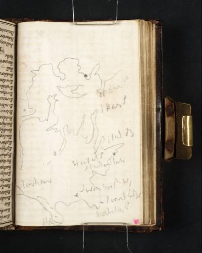
Joseph Mallord William Turner Sketch Map of Poole Harbour and the Isle of Purbeck 1811

Joseph Mallord William Turner 1775–1851
Folio 34 Verso:
Sketch Map of Poole Harbour and the Isle of Purbeck 1811
D08426
Turner Bequest CXXIII 34a
Pencil on white wove writing paper, 117 x 75 mm
Inscribed by Turner in pencil with place names (see main catalogue entry)
 
Accepted by the nation as part of the Turner Bequest 1856
The map is inscribed from the top right clockwise round the coastline to the bottom left (north-east to south-west) in the following sequence: ‘W Ham S’, ‘S Ham S’ (i.e. Hampshire), ‘Stud B’ (Studland Bay), ‘Handfast P’ (Point), ‘Studland [...]’, ‘Swanage Bay’, ‘Pev[...]l [...]’ (Peveril Point), ‘Durlston P’ (now known as Durlston Head, rather than Point), ‘St A’ (St Aldhelm’s or Alban’s Head), ‘T[...]ham’ (probably Tyneham).
Given that the map is drawn well on in the book, Turner perhaps copied it en route from a printed map or, given the lack of inland features, a navigational chart. In his haste he has rather compressed the lateral proportions. While the coastline is characteristically convoluted, it is not very accurate, although the juxtaposition of place names is correct. It is the only such sketch map made in relation to the 1811 tour.
Turner entered Purbeck from Poole, marked with a dot to the north-east but not named. He drew there (see folios 14 recto and 16 recto; D08387, D08391) before perhaps crossing Poole Harbour rather than taking the longer way round by land via Wareham in the west, and at Corfe Castle and Swanage in the Corfe to Dartmouth sketchbook (Tate; Turner Bequest CXXIV). The castle lies at the centre of the Purbeck peninsula, north-east of Tyneham and north of St Aldhelm’s Head, and may be indicated by the small rounded shape drawn at that point.

Matthew Imms
June 2011

How to cite

Matthew Imms, ‘Sketch Map of Poole Harbour and the Isle of Purbeck 1811 by Joseph Mallord William Turner’, catalogue entry, June 2011, in David Blayney Brown (ed.), J.M.W. Turner: Sketchbooks, Drawings and Watercolours, Tate Research Publication, December 2012, https://www.tate.org.uk/art/research-publications/jmw-turner/joseph-mallord-william-turner-sketch-map-of-poole-harbour-and-the-isle-of-purbeck-r1136903, accessed 20 April 2024.