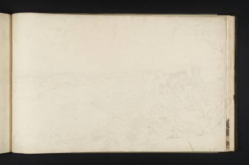
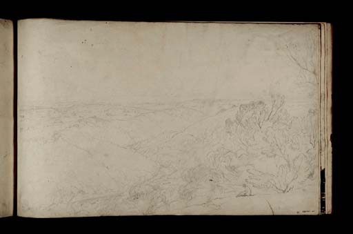
Joseph Mallord William Turner On the River Ure at Hackfall, Looking South-South-East from Mowbray Point c.1816
Image 1 of 2
Joseph Mallord William Turner,
On the River Ure at Hackfall, Looking South-South-East from Mowbray Point
c.1816
Joseph Mallord William Turner 1775–1851
Folio 38 Recto:
On the River Ure at Hackfall, Looking South-South-East from Mowbray Point c.1816
D09054
Turner Bequest CXXVIII 38
Turner Bequest CXXVIII 38
Pencil on white wove paper, 285 x 460 mm
Inscribed by Turner in pencil, ‘Willows’, ‘oak’, Rock’, ‘G[rass]’, ‘corn’, ‘Eure’,
Stamped in black ‘CXXVIII 38’ bottom right
Stamped in black ‘CXXVIII 38’ bottom right
Accepted by the nation as part of the Turner Bequest 1856
Exhibition history
1879
University Galleries, Oxford, 1879 until at least 1909 (94–179).
References
1909
A.J. Finberg, A Complete Inventory of the Drawings of the Turner Bequest, London 1909, vol.I, p.361, CXXVIII 38, as ‘“Wharfedale?”’.
1980
David Hill, Stanley Warburton, Mary Tussey and others, Turner in Yorkshire, exhibition catalogue, York City Art Gallery 1980, p.38, no.46.
With folio 37 from this sketchbook (D09053) this is one of two detailed studies of Hackfall on the River Ure between West Tanfield and Masham. Here, Turner records the view looking south-south-east from Mowbray Point down the Ure with Fisher’s Hall among trees lower centre. In the far distance are the North Yorks Moors and Howardian Hills, and in the right foreground is an artist sketching. Hackfall was laid out by William Aislabie in about 1750. His father, John Aislabie was responsible for the celebrated gardens at nearby Studley Royal and Fountain’s Abbey. William Fisher was their head gardener and the building near the river was named after him. Turner will have known of Hackfall through The Works of the Late Edward Dayes, published in 1805, to which he was a subscriber. Dayes had visited Hackfall on a tour of Yorkshire and Derbyshire in 1803, and devoted a distinct section of his account to its description,1 recommending this viewpoint in particular.
The sketch served as the basis of a studio watercolour, The River Ure at Hackfall, near Ripon, Yorkshire (private collection). Spatters of watercolour in the sky in the drawing presumably occurred as Turner worked on the watercolour, which follows the topographical details closely, albeit with some exaggeration for effect, but replaces the seated artist at the bottom right with a boy apparently bird-nesting. Turner visited the area in 1816 and the Yorkshire 1 and Yorkshire 3 sketchbooks contain comparable views in the vicinity (Tate D10943–D10946, D11387–D11394; Turner Bequest CXLIV 40 a–43, CXLVI 11a–16). The right half of an extended sketch in the Yorkshire 1 sketchbook (Tate D10943–D10944, D10945; Turner Bequest CXLIV 40a–41, 42) is particularly close, albeit taken from a slightly lower viewpoint. It seems highly probable that the subject was one of those commissioned by the publishers Longmans to illustrate Thomas Dunham Whitaker’s projected seven-volume General History of the County of Yorkshire.2 The 1816 tour was made specifically to gather material for this project, and the studies in the present book appear to represent the culminating studies of his exploration of the site. This offers some suggestion that these sketches at least, and possibly the whole sketchbook, might be dated to 1816.
Verso:
Blank, except for an inscription in ink by an unknown hand in a cartouche ‘262’, bottom right, and in blue pencil ‘8’, towards top left
David Hill
October 2009
How to cite
David Hill, ‘On the River Ure at Hackfall, Looking South-South-East from Mowbray Point c.1816 by Joseph Mallord William Turner’, catalogue entry, October 2009, in David Blayney Brown (ed.), J.M.W. Turner: Sketchbooks, Drawings and Watercolours, Tate Research Publication, September 2014, https://www


