Joseph Mallord William Turner Headland Views along the South Coast of England c.1821-2
Image 1 of 2
-
 Joseph Mallord William Turner, Headland Views along the South Coast of England c.1821-2
 -

") Joseph Mallord William Turner, Headland Views along the South Coast of England c.1821-2 (Enhanced image)Enhanced image
Joseph Mallord William Turner, Headland Views along the South Coast of England c.1821-2 (Enhanced image)Enhanced image

Joseph Mallord William Turner,
Headland Views along the South Coast of England
c.1821-2
Joseph Mallord William Turner 1775–1851
Folio 57 Recto:
Headland Views along the South Coast of England c.1821–2
D17300
Turner Bequest CXCVIII 57
Turner Bequest CXCVIII 57
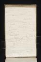
Pencil on white wove paper, 187 x 113 mm
Inscribed by Turner in pencil ‘Beachy Hd’ top left, ‘Berry Hd’ towards top centre, ‘Portland Bill’ towards top right, ‘WNW’ above and left of centre, ‘Ram Hd’ above and right of centre, ‘Yealm River’ left of centre, ‘Bolt Tail’ right of centre, ‘Mewstone’ below and left of centre, ‘Needles E’ below and right of centre, ‘St albans Hd’ towards bottom left, ‘Peveril Point’ towards bottom left, ‘Swanage Bay’ towards bottom centre, ‘Bolt Hd’ bottom left, ‘Praul P’ bottom centre
Inscribed by John Ruskin in red ink ‘57’ top right, ascending vertically
Stamped in black ‘CXCVIII – 57’ top right, ascending vertically
Accepted by the nation as part of the Turner Bequest 1856
References
1909
A.J. Finberg, A Complete Inventory of the Drawings of the Turner Bequest, London 1909, vol.I, p.605, CXCVIII 57, as ‘“Beachy Head,” “Portland Bill,” “W.N.W.,” “Rame Head,” “Bolt Tail,” “Yealm River,” “Mewstone,”’ “Needles Z,” “St. Albans Head,” “Peveril Point,” “Swanage Bay,” “Bolt Hd.,” “Prawle Point.”.
1990
Eric Shanes, Turner’s England 1810–38, London 1990, pp.127 under no.99, 284 note 94.
This is one page out of a total of nine upon which Turner records copies of engravings from The Little Sea Torch. Written by Richard Bougard, the illustrated text was translated from the French by J.T. Serres and published in London in 1801.1 For more detailed information about the book, and an interrogation of Turner’s use of it, see the sketchbook Introduction. For the other pages in the sequence, see the entry for folio 55 recto (D17296).
On the present page Turner produces a visual list of headland views from the reference text, all made with the sketchbook turned vertically. There are eleven individual drawings on this page, realised to varying degrees of elaboration.
A great number of inscriptions by Turner’s hand are included on this page, the first positioned at the very top, towards the left. As noted by Finberg this reads ‘Beachy Hd’.2 The south-facing Beachy Head cliffs are the tallest chalk sea cliffs in the United Kingdom, situated towards the western end of the Eastbourne coastline.3 The name is derived from two French terms: ‘Beauchef’, and ‘Beaucheif’, which mean ‘beautiful head(land)’.4 Turner notes down a view of the cliffs at the top of this page, emulating engraving 5 on plate 3 in The Little Sea Torch, which is titled, ‘Beachy Head from the S.W’.5
Immediately below is a second inscription: ‘Berry Hd’. This and the associated drawing underneath are copied from the first engraving on plate 4 of Bougard’s book, which is described as depicting ‘The Berry Head. S.W’.6 Berry Head is a headland situated towards the southeast of Brixham in Devon;7 the artist had sketched the fortifications there in 1811 in the Devonshire Coast, No.1 sketchbook (Tate D08557; CXXIII 99a). The 1801 engraving describes and annotates the dark shape of the ‘Dartmouth Mewstone’ towards the left, a landmark that Turner also includes at left in his sketch.
Moving down the page, towards the right is a third inscription. Finberg transcribes this as ‘Portland Bill’, which is a narrow peninsula at the southern end of the Isle of Portland, also the southernmost point of Dorset.8 In the drawing immediately below, Turner renders a view in which hatched headlands overlap as they recede into the distance. Taken from plate 3 of The Little Sea Torch, this view recreates the seventh engraving, ‘The Bill of Portland’.9 The artist visited Portland in 1811; see in particular Tate D08837 and D08838 (Turner Bequest CXXIV 26, 27) in the Corfe to Dartmouth sketchbook.
Next, towards the left, is the inscription, ‘WNW’. West-northwest is the compass point halfway between due west and northwest, 67°30' west of due north. Parallel with this, on the far right of the page, is the inscription ‘Ram Hd’. Ram Head, sometimes referred to as Rame Head as per Finberg’s identification, is a headland at the south-eastern tip of Cornwall, topped with a medieval slate church. 10 The chapel is a clear presence within the drawing on the present page. It is rendered as an angular deviation in the line which also describes the crest of the hill upon which the building sits. The mainland stretches out behind the peninsula on both sides. This sketch and its associated inscriptions are taken from the second engraving on plate 4 of The Little Sea Torch, titled ‘The Ram Head W.N.W’.11 Turner had sketched it in 1813; see for example Tate D09275 (Turner Bequest CXXXI 53) in the Plymouth, Hamoaze sketchbook.
At far right, towards the middle of this page, a single-line drawing describes Bolt Tail in Devon, as declared by the inscription on the very edge of the paper.12 The topography of this headland is explored in more detail on the facing page of the sketchbook, folio 56 verso (D17299). Here, the simply rendered headland is an extension of the drawing below; Turner has run out of space on the right hand side and shifted the final segment of the sketch into the free space it currently occupies.
Parallel with the drawing of Bolt Tail is another inscription towards the far left; ‘Yealm River’.13 The Yealm is in Devon and travels 12 miles to the sea, ‘streaming through hungry and lean lands’.14 Like Ram Head, discussed above, the mouth of the Yealm River is on the southern coast of Devon. The two are separated by a bay known as the Plymouth Sound; Ram Head to the west, the Yealm to the southeast. There a few drawings along the Yealm Valley in the Plymouth, Hamoaze book.
The motivation for Turner’s ‘Yealm River’ inscription is the full-width sketch of rocks and cliffs on the coast that sits immediately below. On the left, a rocky island is inscribed ‘mewstone’, which identifies the location as another Devon scene. The Great Mewstone is also described in two sketches at the top of the previous page, folio 56 verso (D17299), where Turner’s own experience of it is noted. The stone sits about half a mile out from Wembury Point in south Devon.15 Here Turner copies his view from ‘Plymouth Mewstone’, the third engraving on plate 4 in The Little Sea Torch.16 The right hand section of the engraving, which describes and annotates the ‘Bolt Tail’ headland in the distance, does not fit within the dimensions of Turner’s page. So, as previously discussed, he transfers this final portion to an area of free space above.
The next drawing down on this page is associated with an inscription at far right, which Finberg interprets as ‘Needles Z’.17 The marking identified by Finberg as ‘Z’ seems more likely to be ‘E’, denoting compass point ‘East’. The drawing that occupies the space beneath this inscription does describe the distinctive topography found at the Needles on the western extremity of the Isle of Wight, off the coast of Hampshire. The famous group of rocks are part of a chalk band which runs through the centre of the Isle of Wight from Culver Cliff in the east, and continues west along the seabed to the Isle of Purbeck in Dorset.18 This ridge was breached in around 5,000 BC by the Solent River, isolating the island from the mainland and leaving behind only these resilient vertical sections of particularly hard rock.19 Their name is believed to have been inspired by a very slim, tapered shard, which collapsed in 1764 leaving a treacherous stump that still emerges at low tide.20 Turner had first been in their vicinity in 1795; see the Isle of Wight sketchbook (Tate D00450; Turner Bequest XXIV 42).
Turner’s impression of the Needles is taken from the fourth engraving on plate 4 of The Little Sea Torch.21 An architectural structure is indicated at the top of the cliffs, towards the right in both versions of the scene. This might be the lighthouse built to Richard Judd’s designs in 1785 following a petition from merchants and ship owners.22 The tower was later abandoned, since its elevation 144 metres above sea level left the light often obscured by inclement weather conditions.23
The sketch which follows has been discussed by Eric Shanes in Turner’s England 1810–38.24 An inscription on the left reads ‘St Albans Hd’. St Alban’s Head is the corrupted name given to St Aldhelm’s Head, which juts out into the sea along the Dorset coast, to the southwest of Swanage, forming part of the Jurassic Coast.In explication of the finished watercolour Off St Alban’s Head of about 1818–22 (Mercer Art Gallery, Harrogate Museums and Arts),25 Shanes describes how Turner recorded two drawings of this subject in this sketchbook. Shanes finds the configuration of the headland in one of these sketches ‘virtually identical’ to that outlined in the distant background of the watercolour.26
In any case, the present view entertains the subject of St Albans Head, as observed in the fifth engraving on plate 4 of The Little Sea Torch.27 Both versions of the prospect describe not only the cliff-face and jagged rocks at sea level, but also the stone Chapel of St Aldhelm stationed on top, thought to date from the Norman period.28 Turner makes a very brief, vertical mark on the topmost edge of the squat building that is not present in the original engraving. Quite possibly a slip of the pencil, this might alternatively indicate a feature which has since been replaced with a stone crucifix. Structural conservation in recent years has uncovered evidence to suggest that in the past a beacon was fixed in this position.29
Beneath the drawing of St Albans Head, there is a small sketch towards the right. Once again, this is the tail end of a drawing below which proved too wide for the page. It describes Old Harry, the name given to chalk rocks off Handfast Point in Dorset.30
The view to which Old Harry belongs comes from plate 4 of The Little Sea Torch, which is the sixth engraving on that sheet and is titled ‘Piveral Point N.bE.’.31 Turner annotates his sketch with two inscriptions. The first, ‘Peveril Point’, is on the far left and employs the correct spelling for the name of the Dorset headland, and the second, ‘Swanage Bay’ sits at centre followed by an unidentified pencil mark, perhaps made accidentally.32 Peveril Point forms the southern edge of Swanage Bay in south east Dorset, and is described here as a hatched, tapering headland in the foreground on the left. Shading added to describe the undulating landscape on the right has smudged a little. Turner had explored the Swanage area by land in 1811; see the Corfe to Dartmouth sketchbook (Tate D08819–D08822; Turner Bequest CXXIV 12, 13, 14, 15). He was to see the coast from the English Channel in 1827, as recorded in the Windsor and Cowes, Isle of Wight sketchbook (Tate D20647; Turner Bequest CCXXVI 31).
At the bottom of the page, pressed into the gutter of the sketchbook in places, is a drawing inscribed ‘Bolt Hd’ on the left and ‘Praul P’ towards the right. Both Devon subjects feature in sketches on the surrounding pages; Bolt Head on folio 56 verso (D17299) and Prawle Point on folio 56 recto (D17298). Bolt Head is also entertained much later on, on folio 80 verso (D17344). For more information on the geography and topography of both locations, see the entries for those pages. The drawing here emulates engraving number ‘7’ on plate 4 of The Little Sea Torch.33
Richard Bougard, The Little Sea Torch: or, True Guide for Coasting Pilots: by which they are clearly instructed how to navigate along the coasts of Malta, Corsica, Sardinia, and others in the Straits; and of The Coast of Barbary, from Cape Bon to Cape de Verd, trans. with corrections and additions by John Thomas Serres, London 1801. For an online and PDF facsimile, see ‘The Little Sea Torch’, accessed 26 October 2015, Biblioteca Nacional de Portugal, http://purl.pt/23500 .
‘Beachy Head in Eastbourne’, Visit Eastbourne, accessed 6 November 2015, http://www.visiteastbourne.com/things-to-do/BeachyHead.aspx .
‘About Beachy Head’, Beachy Head Countryside Centre, accessed 6 November 2015, http://www.beachyhead.org/About.html .
‘Plate 3’, The Little Sea Torch, accessed 6 November 2015, http://purl.pt/23500/1/index.html#/155/html .
‘Plate 4’, The Little Sea Torch, http://purl.pt/23500/1/index.html#/157/html , accessed 6 November 2015.
‘Berry Head Location Map’, Countryside Trust, http://www.countryside-trust.org.uk/berryhead , accessed 6 November 2015.
‘Polwhele’s Devonshire’, Murray’s Hand-Book for Devon and Cornwall, quoted by Samuel Lewis in The Book of English River: An Account of the Rivers of England and Wales, London 1855, p.445.
‘The Great Mewstone’, South Devon AONB, accessed 6 November 2015, http://www.southdevonaonb.org.uk/explore/wembury/the-great-mewstone .
‘The Needles Rocks’, The Needles Landmark Attraction, accessed 6 November 2015, http://www.theneedles.co.uk/pages/needles-rocks .
‘Needles’, Trinity House, accessed 6 November 2015, http://www.trinityhouse.co.uk/lighthouses/lighthouse_list/needles.html .
‘Chapel of St Aldhelm’, National Coastwatch, http://www.nci.org.uk/stations/chapel-st-aldhelm , accessed 6 November 2015.
‘Old Harry Rocks’, Jurassic Coast: Dorset and East Devon World Heritage Site, http://jurassiccoast.org/rocks-and-fossils/the-science-of-a-beautiful-landscape/1014-old-harry-rocks , accessed 6 November 2015.
Technical notes:
The top edge of the page is a little ragged towards the left corner.
Maud Whatley
January 2016
How to cite
Maud Whatley, ‘Headland Views along the South Coast of England c.1821–2 by Joseph Mallord William Turner’, catalogue entry, January 2016, in David Blayney Brown (ed.), J.M.W. Turner: Sketchbooks, Drawings and Watercolours, Tate Research Publication, February 2017, https://www