In existing studies of Dennis Oppenheim’s Salt Flat 1968 (Tate T01773), and land art more generally, the sites the artist engages with are often regarded as essentially anonymous: a river, a field, a hillside, a parking lot. They could be anywhere. They are generic and interchangeable, landscapes that function only as blank canvases for the artist’s actions. Even when these sites are presented in Oppenheim’s documentations with great specificity – like the indication that Landslide 1968, a notable early work that involved a series of parallel wooden boards placed on a steep embankment, was created in an old gravel pit off of Exit 52 of the Long Island Expressway – these specific locations seem unremarkable. They serve as reminders of the ‘indexical’ quality of documentary presentation; the actual specificity of Oppenheim’s sites seems perfunctory, with little impact on the work in terms of content. Such blankness surely structures the conventional understanding of Salt Flat: the parking lot on which Oppenheim spread salt was literally empty (a prerequisite for creating the work; it would not have been possible to use a lot crowded with cars or people), but the site also appears to be empty in a figurative sense, a place separate from the world around it.
But can we really limit interpretation to the abstractions of anonymous locations, to the blankness of site? What do we lose when we separate these sites from the world? Despite Oppenheim’s apparent scepticism towards the significance of site, and the way his works seem to emphasise locations merely to affirm the index, the places he used were real places. What happens to our conception of Landslide, for example, when we learn that its location near the Long Island Expressway is now covered in parking lots – a transformation that seems to connect the work across time to the parking lots in Salt Flat? Or that it took place very near Pilgrim State Hospital, the largest psychiatric facility in the world? Oppenheim made his psychiatric treatment part of his later work; such a connection seems to implicate Landslide in this turn towards the body. The documentation thus invites us to contemplate very particular locations. In Salt Flat, after all, Oppenheim details the exact intersection at which his parking lot is situated, and even locates it on a precise map.1 Furthermore, while the photograph of Oppenheim and his salt rectangle is abstracted, it contains enough visual information to position the action with specificity. Rather than violating the internal logic of Oppenheim’s works, such a historical reconstruction affirms the value of site in his practice.

Fig.1
Dennis Oppenheim
Salt Flat 1968
Photograph, map and typescript on board
711 x 559 mm
Tate T01773
© Dennis Oppenheim. Courtesy of the Dennis Oppenheim Estate, New York

Fig.2
Photograph of 6th Avenue (Avenue of the Americas) near 26th Street, New York, c.1983–8
City of New York, Department of Finance, NYC Department of Records, Manhattan 1980s Tax Photos Collection
The work’s documentary photograph depicts, for example, a brick building behind the lot that has a set of three windows punctuating a whitewashed wall; two windows are close together and one is further away (fig.1). Scrutinising these minor details is key. From 1983 to 1988, New York City’s Department of Finance made photographs of every property in the city for use in assessing property tax. Of the photographs taken on 6th Avenue at 26th Street, one blurry, low resolution image shows the entire block facing 6th Avenue completely levelled, with the side facades of the tall buildings lining the side streets fully exposed (fig.2). The building second from the left is whitewashed and its pattern of windows is recognisable: a set of three windows, two closer together and one further away. It matches Oppenheim’s parking lot exactly.
The parking lot as palimpsest

Fig.3
Sixth Avenue Looking Southwards from West 26th Street, After Removal of El. February 19, 1939, 1939
Photographic views of New York City, 1870s–1970s, collections of the New York Public Library, New York

Fig.4
Sixth Avenue, East Side, North from West 25th Street. January 29, 1920, 1920
Photographic views of New York City, 1870s–1970s, collections of the New York Public Library, New York
The site used by Oppenheim is an unexpected palimpsest of New York City’s history. In 1985 the New York Times described the area in terms of urban decay and possible renewal. ‘South of 31st Street, below Herald Square, the avenue frontages are filled mainly with rundown turn-of-the-century walk-ups and sundry ground-floor commercial uses – import-export shops, hardware stores, small restaurants … [M]any sites in the mid-20s are totally vacant, suggesting long-standing assemblages awaiting a development opportunity.’2 But the site had not always been decrepit. Another photograph, also taken by the city, captures the same view looking south on 6th Avenue from 26th Street in 1939 (fig.3). It shows a long row of tidy brownstone shopfronts, a quiet boulevard with trolley tracks and a single parked car; another automobile drives off in the distance. The 6th Avenue Elevated railway that rattled above was razed that year in order to let light and air onto the avenue, and a new subway line was completed in 1940 to prime the stretch for further development. Looking north on 6th Avenue from 25th Street in another photograph, this time from 1920, the character of this block comes into focus: we see a hardware store, a billboard advertising Gulden’s brand mustard, a sign for Ever-Ready Razors – the urban array of a bustling metropolis (fig.4). All were levelled in the creation of barren parking lots.
Sifting through layers of the site’s history, we also learn that the Astors, the wealthy land-owning New York City aristocrats, once owned the parcels fronting 6th Avenue. The land was bought and sold in rapid succession during the boom years of the 1920s, changing hands quickly from a Nathan Wilson to the Evolution Reality Company, the Alkov Real Estate Corporation and the Coleman Holding Corporation.3 There were plans in the 1920s for developing the assembled lots, comprised then of fourteen existing three- and four-story buildings, into ‘twenty-four story commercial structures with stores on the avenue and side streets’.4 Later, in the 1940s, there was a planned ‘nineteen-story and penthouse store and apartment building’.5

Fig.5
Martin Schapiro
Chelsea Landmark Building 2017
Photograph
© Martin Schapiro
But the flight of the middle class to suburbia and the decline of New York’s manufacturing sector, centred in part on this Chelsea neighbourhood, left vast swathes of downtown Manhattan decrepit and abandoned; the land was more valuable for temporarily housing automobiles than it was for permanently housing people. Buildings were demolished and paved over, making way for a desert of bleak parking lots. In the 1960s the New York Times reported: ‘At least half a dozen parking lots and gas stations line the one-mile stretch of Sixth Avenue … One of the largest is on the east blockfront between 25th and 26th Streets. The vacant plot covers 25,000 square feet, and Theodore Locker, who holds a long-term lease on it, is thinking about putting up an apartment house.’ The planned building was imminent. ‘Mr. Locker said it was just a matter of time – “a year or two at most” – before he could build his apartment house.’6 Instead, the parking lots were used for a popular weekend flea market, filled with tables of bric-a-brac and vintage clothing.7 By the 1980s, with construction delayed for decades, the bombed-out and bulldozed sites extended north and south for blocks. More recently, gentrification has transformed the area. In 2007 the site was finally redeveloped. The Chelsea Landmark, a luxury rental apartment building that opened that year, now occupies it (fig.5). In addition to a lush landscaped roof deck and a lounge, it offers such amenities as a ‘game room with golf simulator and billiards, library, party room, fitness center and patio with barbeque grills’.8 The name of this new structure is apt. The Landmark replaced ‘land marked’ by Oppenheim just decades prior. The building’s website even advertises its proximity to Chelsea’s art galleries.

Fig.6
Sanborn Map Company
Detail from Atlas 42.54., vol.4, 1890: Manhattan, double page plate no.69
New York Public Library, New York
These descriptions are not just a matter of historical curiosity. In Salt Flat the accumulation and dispersal of salt echoed the accumulation and dispersal of materials – brick and brownstone – used in the buildings that rose on the site only to be later erased in asphalt. The shape of the salt form – the rectangle – even mimicked the shape of the individual bricks and stones that once formed structures at the site. The rectangle is also the building block from which the Manhattan street grid is composed; long distances between avenues and short distances between streets create a regular, repeating grid that extends north from lower Manhattan. Individual city blocks are further subdivided. In a detail from an 1890 atlas of Manhattan showing this stretch of 6th Avenue, the blocks of the street grid are broken into perfect rectangular parcels – the geometrical regularity at this single site is striking (fig.6). The map’s pink tone also reiterates the colour of the salt rectangle under the setting sun in Oppenheim’s photographic documentation, as if Oppenheim superimposed the forms from this map directly onto the actual landscape.
The anonymous parking lot in Manhattan is a site of construction and destruction, a physical manifestation of the brutal economic ordering of space. The mass of salt represents the transformations of capital, the wealth and power that accumulate and slowly disappear on this single plot of land. Oppenheim restaged the transformations of the site over the long durée of its history by compressing that history, from a distant past as farmland to a distant future (and now present) as a luxury high rise, into a single day in November of 1968.
Desert to sea
Salt Flat takes place not only on a parking lot in Manhattan, however. The work’s documentation also points to excavations and accumulations afar, in the high desert and the deep sea. These sites are also crucial for making sense of Salt Flat.
Firstly, the desert: like the parking lot in Manhattan the location of the proposed salt excavation, the Great Salt Desert, seems abstract and distant, far removed from Oppenheim’s lived experience in New York City.9 There is not much in the Great Salt Desert – just an endless expanse of sand, rock and crystalline salt, the barren remains of an ancient sea that once spanned hundreds of square miles.
But Oppenheim’s reference is more specific. In the southeast corner of the Great Salt Desert there is a tiny town called Dugway. The town’s name literalises Oppenheim’s proposed action; semantically dismantling the name Dugway renders ‘dug away’, as in to remove or excavate. This is, of course, the action Oppenheim proposed in digging away blocks of salt from the desert surface (his text for Salt Flat explicitly uses the word ‘dug’: salt blocks ‘dug to a 1’ depth’). Dugway is also notable for a nearby military installation, Dugway Proving Ground, which was established in 1942 for chemical and biological weapons testing. Just months before Oppenheim created Salt Flat, Dugway Proving Ground made headlines across the country after some six thousand sheep grazing in a valley roughly thirty miles from the site suddenly and mysteriously died. The incident was later linked to tests of a lethal nerve agent called VX, which had been released by aircraft during a weapons test. A malfunctioning spray nozzle caused the chemical to be dispersed at a higher altitude than intended, and it subsequently wafted through the air to the neighbouring valley. The incident became a flashpoint for anti-war activists advocating disarmament, as the chemical’s toxicity raised troubling ethical questions about modern warfare during the cold war.10 To what degree do these sites and these events intersect with Salt Flat? How does the dispersal of salt in Manhattan relate to the dispersal of a toxic nerve agent in Utah?

Fig.7
Dennis Oppenheim
Acetate overlay used in printing documentations
Dennis Oppenheim Estate, New York
Oppenheim was interested in salt as an artistic material precisely because he understood it as a volatile chemical, one that changes states (from solid blocks to granular power to liquid solution) and even transforms other materials through its reactive and corrosive potential. In a series of succinct statements in a notebook dated April 1968, roughly the same time the news media first reported the Dugway sheep kill, Oppenheim lists ideas for possible projects using chemicals – ‘subject chemical elements to alternate forces’ and ‘chemical break-down’ – and notes possible characteristics of such works: ‘chemical dictates shape – responds only to gravity, extension and inertia’. In a similar notebook from November 1968 – the same month he created Salt Flat – Oppenheim specifically references salt as a chemical agent; he refers to ‘cloud seeding’ or creating rain through ‘salt particles used to create large ice nucleus in clouds’.11 Oppenheim’s interest in chemical processes parallelled the reporting of events at Dugway Proving Ground; not only did he consider using chemicals but he also contemplated spraying them into the atmosphere, a process that echoes the aerial testing at Dugway. Even if Oppenheim had been unaware of such connections, he would likely have known that the Great Salt Desert was also home to Wendover Air Force Base, the site of the US Air Force’s largest bombing range during the Second World War (it closed in 1969). This history is even indexed in the work’s documentation. Art historian Stephan Bann notes that the target over the documentation’s map locating the site in Manhattan ‘looks suspiciously like a gun-sight, as if some airborne weapon were targeting the work for destruction’.12 Oppenheim created an acetate overlay of a target pattern that he could print into photographs – effectively dropping the target itself into the image – for later documentations of other works (fig.7). These artistic clues suggest Oppenheim’s awareness of his site’s troubling history.
Similarly, the location of the proposed salt dumping, planned to take place in ‘the Bahamas’, seems wholly abstract. It brings to mind any number of tropical ocean locales, far removed from New York City. But again, perhaps Oppenheim’s reference is more specific. The southernmost island in the Bahamas chain, called Great Inagua, has been used in salt production for centuries. The Morton Salt Company, famous for its ubiquitous table salt, produces 1m US tons (900m kilograms) of the crystalline substance on Great Inagua every year; the company has operated a major salt production facility on the island since 1954, when they acquired a plant previously owned by West Indian Chemicals.13 One of the islands at the tip of the Bahamas archipelago, technically part of the Turks and Caicos Territory rather than the Commonwealth of the Bahamas, is even named Salt Cay. The tiny triangular island was once the centre of global salt production. The island’s natural salt pans – shallow pools near the ocean – flood daily; as the water recedes, the salt that remains can be raked, collected and packed for export, as it was for centuries.
Like the farming of colonial cash crops such as sugarcane or the mining of gold and silver, salt production in the New World was deeply exploitative. The British brought slaves to work the salt pans of the Bahamas in the eighteenth century; even after emancipation in 1833, brutal manual labour and horrendous working conditions defined salt production. The industry declined sharply in the twentieth century and by 1968, when Oppenheim created Salt Flat, the salt pans on Salt Cay were finally abandoned (the Morton facility on Inagua continues operation to this day).14

Fig.8
Dennis Oppenheim
Salt Flat 1968
Photographic documentation
Dennis Oppenheim Estate, New York
© Dennis Oppenheim. Courtesy of the Dennis Oppenheim Estate, New York
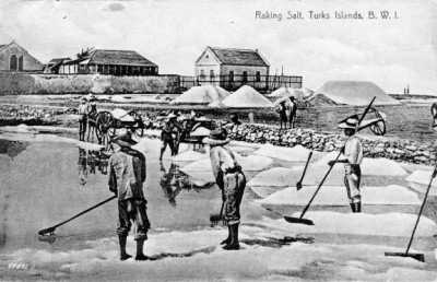
Fig.9
Postcard showing salt raking in Grand Turk, Turks and Caicos Islands, early twentieth century
Turks and Caicos National Museum, Grand Turk
Salt Flat explicitly relates to working the salt pans. Photographs of Oppenheim using a broom to spread salt over the pavement in Manhattan – not used in Tate’s version of the Salt Flat documentation, but employed in later iterations – are strikingly similar to photographs depicting workers raking the salt fields in the Caribbean (figs.8 and 9). Oppenheim drags his broom, pushing and pulling piles of salt to form his rectangle, just as workers hunch over rakes and scrape the crusty surface of the pan to remove the mineral deposits that pile up alongside them. This similarity is a reference – however opaque or unexplained – to a disturbing history, and suggests how Oppenheim restaged this history in Manhattan, collapsing past and present into a single moment.
As described through Jack Burnham’s system aesthetics, Salt Flat relates natural systems and social systems. Oppenheim’s process relied on ecological phenomena characteristic of the natural world, like the wind and weather that would disperse the salt and the chemical changes that would turn it into crystalline grains or a saline solution. His process also relied on social phenomena specific to the art world, like the situational, institutional and representational conventions he manipulated through his documentation. Yet Oppenheim’s work also animates history. History is an aesthetic system, we might say, with associations across time and space that are embedded in particular sites and specific substances – the material residues that accumulate and then disperse in the flux of time. The accumulations and then dispersal of salt in Salt Flat reflect this entropic model of history; references to the past and future are metaphorically echoed by and layered onto the natural and social systems engaged in Oppenheim’s work.
These concerns were typical of artists from the period, if not of Oppenheim specifically. Others like Robert Smithson were acutely aware of their works not only as interventions into landscapes and galleries, into sites and non-sites, but also as interventions into history and time. Art historian Jennifer Roberts beautifully demonstrates how Smithson’s Spiral Jetty 1970 in the Great Salt Lake exists in dialogue with the nearby Golden Spike monument, a site that celebrates the completion of the transcontinental railway.15 Spiral Jetty carefully plays off the history of the railroad and its mythology of progress – a mythology specifically negated or reversed by Smithson’s spiralling, non-linear, entropic model of time. Although Roberts does not make the connection, Smithson’s conceptual move is closely linked to the systems aesthetics of Jack Burnham, which Smithson extends not only to natural and social systems, but also to historical ones.16
Oppenheim is not typically considered in these terms, as an artist of historical metaphor and meaning, yet his procedures actually map onto the histories of his sites in suggestive ways. Oppenheim would return blocks of salt to the Caribbean, thus metaphorically offering a substance that had been extracted through forced human labour back to its site of origin; he reverses the economy of salt production. He would also take blocks of salt from the Great Salt Desert, removing a chemical compound – one that stands by proxy for the chemicals left by human intervention near the Dugway Proving Ground and the Wendover Air Base – out of the landscape; he negates the accumulation of chemical waste. These processes – reversals, inversions and negations (this concept is consistent with James Nisbet’s commentary in this In Focus project) – make each site’s history a crucial aspect of the work.17
Oppenheim makes it very clear that these two actions at disparate sites far removed from New York City are integral to the piece itself – that what happens on the asphalt parking lot is inextricably linked to these future events, even though both are only tangentially referenced in the work’s documentation. He made this explicit in a 1995 interview with art historian Suzaan Boettger:
Boettger: [Y]ou did a work called ‘Flat’. … [T]his was on Sixth Avenue – was that a dispersal?
Oppenheim: No.
Boettger: It wasn’t.
Oppenheim: No, it was in a parking lot. It was done on a Saturday or a Sunday. There was nobody there. It wasn’t meant to be transactional in that sense, but it was meant to be displaced. In other words, that shape [the rectangle] was to be reproduced on the floor of the ocean with salt, and also desert. So it was radical in that what you saw there was part of a three part piece, which involved thousands of miles in between one another in different sort of conditions of their execution.18
The significance of these two unrealised portions of the work is also evident in Tate’s version of the documentation, in which the text states ‘(part 1)’ in order to make clear that there are future unrealised parts of the piece (numbers 2 and 3); later versions of the documentation would drop this distinction, indicating that Oppenheim later settled on leaving the work alone at part 1. The text also undergoes a slight grammatical change; the Tate documentation, the earliest Oppenheim created, states that these actions ‘are to be’ enacted while later versions replace that phrase with a simple ‘to be’ enacted. The ever-so-minor alteration defers these future actions even further, into a hypothetical future instead of one more closely linked to the present (when Oppenheim created these later versions of the documentation, he had already decided that he would not fulfil parts 2 and 3, which he had originally planned to complete).19 Oppenheim explains, ‘It was really part one of a three part sculpture piece. That was an important aspect of conceptual art, the fact that something could exist simultaneously in three different places.’20
But Oppenheim’s comments to Boettger are also significant because of his chosen terminology. He presents the work not as a ‘dispersal’ (the term used by many critics). Instead, he uses the word ‘displaced’. Salt Flat is a ‘displacement’ not only in the sense that it involved displacing material from one site and into another, but more profoundly in the sense that it displaced the pre-existing relations to that material at each site. It is a metaphorical displacement, one that disrupts the meanings of contexts and their histories. In an important conversation with artist, curator and publisher Willoughby Sharp in his and the artist and writer Liza Béar’s Avalanche magazine, Robert Smithson further describes Oppenheim’s action: ‘I think what Dennis is doing is taking a site from one part of the world and transferring the data about it to another site, which I would call a dislocation.’21
Oppenheim himself uses an even more loaded term to refer to the work. In the same notebook where he considered ‘chemical break-down’ as an artistic process, he also suggests a ‘ruptured salt flat’ – this is actually the clearest reference to Salt Flat in his notebooks. The word ‘rupture’ is key. ‘Dispersal’ of the salt merely suggests its diffusion and subsequent disappearance; ‘displacement’ only indicates the act of moving material from one site to another, even if metaphorically; and ‘dislocation’ simply implies a change to a particular place. The word ‘rupture’ still more dramatically points to the profound intervention Oppenheim makes, one that explodes the work’s accumulated historical references, leaving viewers to relate histories that have been fractured from standard temporality.22
Dislocated sites: Ruptured time and space
It is not clear if Oppenheim was aware of the full set of associations Salt Flat might generate – or even if he wanted his work to function as a surface for projecting such meanings. He rejected the site-specific significance of the Manhattan parking lot (‘The location for Salt Flat wasn’t necessarily site specific’),23 as well as any immediate reference to current events – to the dramatic social upheavals at home and abroad that marked 1968 and might be seen as obliquely quoted through connections to sites like Dugway Proving Ground and Salt Cay. Asked by Boettger if he was interested in issues like ‘civil rights’ or ‘Vietnam deaths’, he states unequivocally that he ‘wanted to shed all of those more emotional references and social references’.24
Yet the histories of such sites still exist; the past and future are present in particular locations. In other remarks, even Oppenheim allows for the possibility that his sites generate meaning, stating that his early land art ‘did not want to refer to the picturesque and to the sublime, it wanted to deal with the rigour of the site as it was a condition of the real world … That’s where the energy of something like the Vietnam War could subliminally get into the blood track of the work.’25 Ultimately, however, it does not matter whether Oppenheim chose his sites with intention. By providing a conceptual framework – a system – that links us to these places, he also allows and even demands that we relate their histories, even if only by imagination. The creation of a system for connecting disconnected sites inevitably also generates associations that extend behind the given framework of the system. In the same interview in which he disavowed ‘emotional references and social references’, Oppenheim explained that he wanted to ‘open up this sort of secret dialogue with this new conceptual landscape’ – a phenomenon he also describes as ‘the dialogue for what Jack Burnham calls system art’.26 Elsewhere, he calls this dialogue the creation of ‘mental configurations’.27 In a 1969 symposium on land art at Cornell University, he referred to this type of work as ‘an art that is inside our head and inside our total system’.28
Salt Flat creates this conceptual framework or system – this dialogue, this set of mental configurations – by converging temporal registers. In leaving future actions unrealised, the work creates a temporal rupture on the asphalt in Manhattan. The leap towards future actions that are never even enacted invites the inverse, opposite leap back in time to historical moments, from those long gone, like the salt raked at Salt Cay, to more immediate pasts, like the chemicals sprayed at Dugway. The work also creates a spatial rupture; the asphalt surface becomes a proxy for the salt in the desert and the salt in the sea.