Joseph Mallord William Turner Sketches of the Cliffs Between Redcar and Whitby and of Whitby 1822
Image 1 of 2
Joseph Mallord William Turner,
Sketches of the Cliffs Between Redcar and Whitby and of Whitby
1822
Joseph Mallord William Turner 1775–1851
Folio 83 Verso:
Sketches of the Cliffs Between Redcar and Whitby and of Whitby 1822
D17655
Turner Bequest CC 83a
Turner Bequest CC 83a
Pencil on white wove paper, 187 x 114 mm
Inscribed in pencil by Turner ?‘Hunt Cliffs’ ‘Tees’ upper centre, ‘Tees’ lower centre
Blindstamped with the Turner Bequest stamp bottom right
Inscribed in pencil by Turner ?‘Hunt Cliffs’ ‘Tees’ upper centre, ‘Tees’ lower centre
Blindstamped with the Turner Bequest stamp bottom right
Accepted by the nation as part of the Turner Bequest 1856
References
1909
A.J. Finberg, A Complete Inventory of the Drawings of the Turner Bequest, London 1909, vol.I, p.613, CC 83a, as ‘View of coast line, mouth of “Tees,” “Whitby,” &c.
1981
Gerald Finley, Turner and George the Fourth in Edinburgh 1822, exhibition catalogue, Tate Gallery, London 1981, pp.86, [226] reproduced as ‘Views of coastline; mouth of “Tees”, “Whitby” etc.’.
1981
Eric Shanes, Turner’s Rivers, Harbours and Coasts, London 1981, p.152.
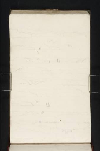
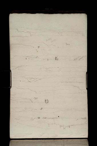
Between sketches of Dunstanborough Castle (folio 83; D17654) and Whitby (folio 84; D17656) Turner made several sketches of the cliffs along the North Yorkshire coast. While many of the cliffs look very similar to each other, several of them can be identified by inscriptions and their proximity in the sketchbook to views of other identified places. Two clues to the location of cliffs on the present page are the inscriptions ‘Redcar’ on folio 83 and ‘Tees’ inscribed twice on the present page.
With the sketchbook turned to the right, the two sketches at the top of folio 83 verso show three headlands seen from the south-east. The second sketch may be labelled ‘Hunt Cliffs’, and the shape of the cliffs indeed matche Huntcliffe and Saltburn which are about four miles south-east of Redcar, and several miles from the mouth of the Tees. The sketch above is either of the same place or of the similar-looking cliffs to the south around Skinny Grove. The seventh sketch down repeats the headland to the right of the second sketch down. Both also include the silhouetted of a three-masted vessel that seems to have been travelling in the same direction as Turner along the east coast.
In the third sketch down, a view of Whitby from the north, the boat has overtaken Turner’s vessel. This sketch shows the North Yorkshire coast from Eastcliff in the east at the left of the picture to Sandsend cliffs in the west at the right (seen again in the sketch below). In the middle is St Mary’s Church.
Towards the bottom of the page are three sketches made with the book turned in the opposite direction; these begin a sequence of sketches around Whitby that continue on folio 84. Two are of cliffs: at the very bottom of the page the sketch is inscribed ‘R H’ (for Robin Hood’s Bay perhaps); the other may be somewhere near Whitby. In the middle sketch St Hilda’s Abbey is prominent with St Mary’s Church to the right, and beneath the cliffs Turner has drawn the semi-submerged crags called The Scar. Eric Shanes has mentioned this sketch as one of several that formed the basis of Turner’s watercolour, Whitby, 1824 (Tate D18143; Turner Bequest CCVIII J).1 In fact this is the closest sketch to the final design which was engraved by Thomas Lupton in 1826 for the Ports of England (Tate T04825). There are similar views of the Whitby coastline on folio 84.
Thomas Ardill
August 2008
How to cite
Thomas Ardill, ‘Sketches of the Cliffs Between Redcar and Whitby and of Whitby 1822 by Joseph Mallord William Turner’, catalogue entry, August 2008, in David Blayney Brown (ed.), J.M.W. Turner: Sketchbooks, Drawings and Watercolours, Tate Research Publication, December 2012, https://www


