Joseph Mallord William Turner Rob Roys' Cave, Loch Lomond; and Sketches Made on the Journey to Islay 1831
Image 1 of 2
Joseph Mallord William Turner,
Rob Roys' Cave, Loch Lomond; and Sketches Made on the Journey to Islay
1831
Joseph Mallord William Turner 1775–1851
Folio 77 Verso:
Rob Roys’ Cave, Loch Lomond; and Sketches Made on the Journey to Islay 1831
D26589
Turner Bequest CCLXX 77a
Turner Bequest CCLXX 77a
Pencil on white wove paper, 201 x 125 mm
Inscribed in pencil by Turner ‘Larg[...]’ top centre, ‘Clyde S’ top right, ‘arran’ upper left, ‘s[...]’ upper centre, ‘arran’ upper right, ‘Toward’ centre right, ‘[...] [...] x Rob Roys Cave’ lower centre inverted
Inscribed in pencil by Turner ‘Larg[...]’ top centre, ‘Clyde S’ top right, ‘arran’ upper left, ‘s[...]’ upper centre, ‘arran’ upper right, ‘Toward’ centre right, ‘[...] [...] x Rob Roys Cave’ lower centre inverted
Accepted by the nation as part of the Turner Bequest 1856
Exhibition history
1982
Turner in Scotland, Aberdeen Art Gallery and Museum, October–December 1982 (71).
References
1909
A.J. Finberg, A Complete Inventory of the Drawings of the Turner Bequest, London 1909, vol.II, p.871, CCLXX 77a, as ‘“Rob Roy’s Cave,” “Clyde S.” “Arran (?),” &c.’.
1982
Francina Irwin, Andrew Wilton, Gerald Finley and others, Turner in Scotland, exhibition catalogue, Aberdeen Art Gallery and Museum 1982, pp.52 cat.71, 53 reproduced fig.71a.
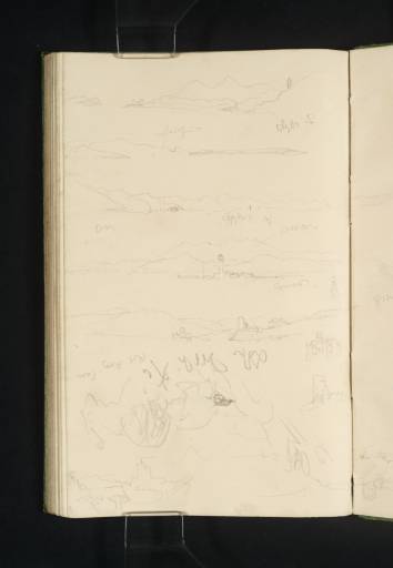
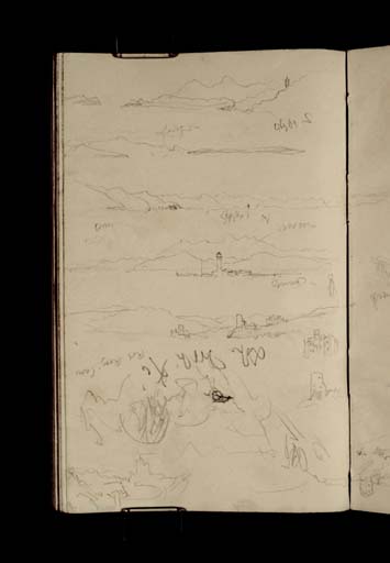
Turner used this sketchbook page on at least two occasions. The first was while he was aboard a steamboat touring the length of Loch Lomond (see folio 23; D26480) on his way from the head of the loch to the landing at Inversnaid (folio 92; D26617). At the bottom of the page, with the sketchbook inverted, Turner drew a rough sketch inscribed ‘Rob Roy’s Cave’. A dark cleft at the centre of the sketch is the cave, which is well hidden within the rocks on the east side of Loch Lomond about a mile north of Inversnaid. Turner would have been keen to see the site, which was associated with Sir Walter Scott, who visited the cave in 1817 in research for his novel, Rob Roy. After making this sketch Turner landed at Inversnaid, from where he travelled on to Lochs Arklet and Katrine, before returning to Inversnaid for the return journey to Dumbarton (see Tour of Scotland for Scott’s Poetical Works Tour Introduction). For further sketches made on Loch Lomond see folio 23 (D26480).
The artist turned back to this page to utilise the blank space while he was aboard another steamboat, this time travelling along the Firth of Clyde to Islay. Having stopped briefly at Dunoon (folio 68 verso; D26571) Turner’s boat steamed south around the point of the Cowal Peninsula. As he rounded the point he made a sketch at the top of the page showing the view south towards the Isle of Arran which lies about fifteen miles away. The view has been identified by the distinctive outline of Goatfell,1 the highest point of the island. The Isle of Bute lies in the foreground, with Great Cumbrae Island at the left. Nearby by at the right is the east coast of the Cowal Peninsula with a tower.
From the same point, or nearby, Turner looked south-east towards ‘Largs’ on the mainland coast. He has inscribed both these sketches ‘Clyde S[outh].’ The inscription of the third sketch down has been read as ‘Clyde N[orth]’,2 making this a view from the same point as the previous sketch, but now looking north up the Clyde and along the east coast of the Cowal Peninsula in the direction of Dunoon.
The fourth sketch down was made just before Turner rounded the point of the peninsula. It carries two helpful inscriptions: ‘– arran’ written above the sketch, and ‘Toward’ beneath. The sketch therefore shows Toward Lighthouse, built by Robert Stevenson in 1812, as seen from the north-east. Across the Kyles of Bute is the Isle of Bute, and beyond that in the distance is the mountainous Isle of Arran, which Turner has moved to the right ‘to get a more effective relation between the lighthouse and the mountain behind.’3 A small sketch to the right may be the lighthouse again, or some other tower.
David Wallace-Hadrill and Janet Carolan have identified the next sketch down as Toward Castle,4 but this needs clarifying. The original Toward Castle was built in the fifteenth century, and was, when Turner saw it, a ruin consisting of little more than the south wall of the tower and part of the courtyard, which are shown at the right of the sketch. At the left, a little further along the coast, is another structure; this may be Castle Toward, an early nineteenth-century country house. The house is drawn in a little more detail beneath the sketch at the right of the page. Beneath this is another building that has previously been identified as Kames Castle,5 but may be the ruins of Toward Castle. At the bottom left of the page is another sketch of a castle ruin. This has been described as ‘an old tower in ruins near Kames’.6 The castle known as Wester Kames Castle (not to be confused with Kames Castle) fits this description and the general appearance of the ruin before it was restored in 1905 (see also folio 77; D26588).
Having passed the Cowal peninsula Turner’s boat stopped at Rothesay (folio 37; D26508) before steaming around the top of the Isle of Bute through the Kyles of Bute, on its way to East Tarbert on Kintyre (see folio 88 verso; D26610). From here Turner crossed the peninsula and took another steamboat to Islay; sketches from the deck of the steamboat of his approach were made on folio 73 verso (D26581).
Thomas Ardill
December 2009
David Wallace-Hadrill and Janet Carolan, ‘Turner Round the Clyde and Islay – 1831’, 1991, Tate catalogue files, folio 8.
How to cite
Thomas Ardill, ‘Rob Roys’ Cave, Loch Lomond; and Sketches Made on the Journey to Islay 1831 by Joseph Mallord William Turner’, catalogue entry, December 2009, in David Blayney Brown (ed.), J.M.W. Turner: Sketchbooks, Drawings and Watercolours, Tate Research Publication, December 2012, https://www


