J.M.W. Turner: Sketchbooks, Drawings and Watercolours

ISBN 978-1-84976-386-8

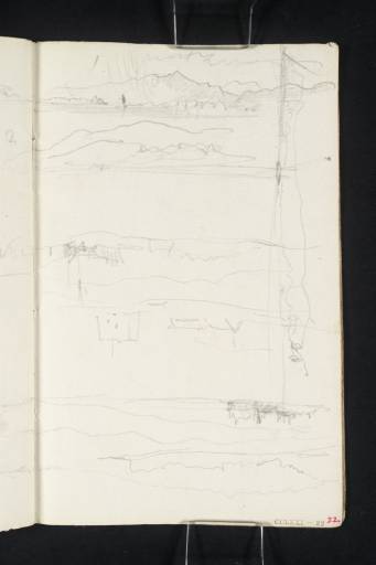
Joseph Mallord William Turner Shores of the Firth of Forth 1831

Joseph Mallord William Turner 1775–1851
Folio 22 Recto:
Shores of the Firth of Forth 1831
D26661
Turner Bequest CCLXXI 22
Pencil on off-white laid writing paper, 158 x 101 mm
Inscribed in red ink by John Ruskin ‘22’ bottom right
Stamped in black ‘CCLXXI – 22’ bottom right
 
Accepted by the nation as part of the Turner Bequest 1856
There are seven sketches of the shoreline of the Firth of Forth on this page, many of which continue on folio 21 verso (D26660). Most of these appear to be of the north shore as the Orchil Hills appear to be in the distance. David Wallace-Hadrill and Janet Carolan have pointed out that the hill in the top sketch is heavily shadowed by the rain clouds above.1 This hill is Dumyat, the western outliner of the Orchil range, meaning that the view is of the north shore, and that the town beneath it must be either Kincardine or Alloa. The sketch is labelled ‘1’ and the sketch beneath it is labelled ‘2’, suggesting that it may be a continuation of the sketch above, probably showing the continuation of the Orchil Hills to the east. Both sketches continue onto folio 21 verso.
With the sketchbook inverted are four further sketches of the shoreline of the Forth, some of them including distant hills. Wallace-Hadrill has suggested that one of the sketches may represent Airth Castle.2 This must be the second sketch down which includes at its left a scribbled shape that suggests gables and turrets. The sketch beneath it shows a tower with the roof of another building to its left. Beneath this is another shoreline sketch, again with the suggestion of buildings in the foreground. All but the third sketch down continue onto folio 21 verso. Although few of these sketches have been identified, it is possible that Turner used the sketchbook in its usual orientation for views of the north shore, and then inverted it to make sketches of the southern shore.
Finally, with the sketchbook turned so that the gutter is at the bottom, is another sketch of the shore of the Firth of Forth. The hills in the distance roughly match those of the second sketch discussed above, suggesting that this may be the north shore near Alloa.
For more information on Turner’s journey up the Firth of Forth, see the inside back cover of this sketchbook (D41132).

Thomas Ardill
October 2009

1
Dr David Wallace-Hadrill and Janet Carolan, ‘Turner’s Sketches North of Stirling’, Turner Studies: His Art and Epoch 1775–1851, Summer 1990 vol.10 no.1, p.15.
2
David Wallace-Hadrill, ‘Sketchbook CCLXXI Loch Long’, [circa 1991], Tate catalogue files.

How to cite

Thomas Ardill, ‘Shores of the Firth of Forth 1831 by Joseph Mallord William Turner’, catalogue entry, October 2009, in David Blayney Brown (ed.), J.M.W. Turner: Sketchbooks, Drawings and Watercolours, Tate Research Publication, December 2012, https://www.tate.org.uk/art/research-publications/jmw-turner/joseph-mallord-william-turner-shores-of-the-firth-of-forth-r1135098, accessed 25 April 2024.