J.M.W. Turner: Sketchbooks, Drawings and Watercolours

ISBN 978-1-84976-386-8

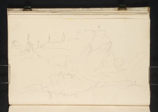
Joseph Mallord William Turner Schloss Wörth above the Strudel, with Burg Werfenstein down the River Danube; a Large Riverside Town 1840

Joseph Mallord William Turner 1775–1851
Folio 33 Verso:
Schloss Wörth above the Strudel, with Burg Werfenstein down the River Danube; a Large Riverside Town 1840
D30063
Turner Bequest CCXCIX 33a
Pencil on cream wove paper, 127 x 198 mm
Partial watermark ‘atman
Inscribed by Turner in pencil ‘Bridge’ below centre, upside down
 
Accepted by the nation as part of the Turner Bequest 1856
With the page turned horizontally, the main view as identified by Cecilia Powell1 is east down the River Danube near the Strudel rapids to the left of the ruins of Schloss Wörth (no longer extant), looming on the rocky Insel Wörth in the foreground; for views on adjacent pages, see under folio 31 verso (D30059). Burg Werfenstein is outlined above the north bank in the distance towards the left; for other views, see under folio 32 recto (D30060).
Discussing Turner’s Danube route between folios 31 verso–38 recto (D30059–D30072;2 like much of this sketchbook, apparently used in reverse of their present foliation), Powell has observed that within a brief stretch of two or three miles his ‘most intensive sequence of sketches, occupying fourteen pages, was made during the steamer’s cautious passage upstream from St Nikola to Grein, past the Wirbel and the Strudel’;3 these hazardous features, shown on old maps respectively east and west of Struden and nearby Burg Werfenstein, no longer exist following the elimination of associated rocks to improve navigation later in the nineteenth century.
Apparently squeezed in towards the top left and the other way up below are two slight views of the spires and skyline of what seems to be a large riverside town, with a written note of a bridge; this remains to be firmly identified. Although Turner’s route upriver was straightforward, his somewhat haphazard use of this book to record it was not. For the geographical sequence of identified views between Vienna and Passau (see under folios 40 recto and 31 recto; D30076, D30058), see this sketchbook’s Introduction.

Matthew Imms
September 2018

1
See Powell 1995, p.241
2
See ibid., p.81 note 32.
3
Ibid., p.68.

How to cite

Matthew Imms, ‘Schloss Wörth above the Strudel, with Burg Werfenstein down the River Danube; a Large Riverside Town 1840 by Joseph Mallord William Turner’, catalogue entry, September 2018, in David Blayney Brown (ed.), J.M.W. Turner: Sketchbooks, Drawings and Watercolours, Tate Research Publication, December 2019, https://www.tate.org.uk/art/research-publications/jmw-turner/joseph-mallord-william-turner-schloss-worth-above-the-strudel-with-burg-werfenstein-down-r1196913, accessed 24 April 2024.