J.M.W. Turner: Sketchbooks, Drawings and Watercolours

ISBN 978-1-84976-386-8

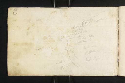
Joseph Mallord William Turner Sketch Map of Ennerdale and Surroundings, with Notes (Inscriptions by Turner) 1809

Joseph Mallord William Turner 1775–1851
Inside Front Cover:
Sketch Map of Ennerdale and Surroundings, with Notes (Inscriptions by Turner) 1809
D07537
Turner Bequest CX
Pencil on white laid paper, 116 x 185 mm
Inscribed extensively by Turner in pencil (see main catalogue entry)
 
Accepted by the nation as part of the Turner Bequest 1856
The map shows a stretch of land south of Cockermouth including a rough outline of Ennerdale, and a route across country towards Cleator to Egremont, Whitehaven and St Bees. Various places of interest and scenic highlights are marked, not all legible or identifiable. Those that are, from left, are ‘St Bees’, ‘White’[haven], ‘Egremont’, ‘Cleator’, ‘Stock[how] Hall’, [Crossdale] ‘Beck’ and ‘Pardshaw’, and the mountains ‘Steeple’, ‘Pillar’, ‘High Style’[sic], ‘Gavel Fell’, ‘Blake Fell’, ‘Red Pike’ and ‘Murton’ [Fell]. An itinerary back south from Egremont is given on folio 1 (D07538).
For Ennerdale see for example folio 25 (D07566); Whitehaven, folio 39 (D07581); St Bees, folio 35 (D07577); and Egremont, folio 26 (D07567). Further drawings are in the Petworth sketchbook used on the same tour (Tate D07512–D07536; D40276; Turner Bequest CIX).

David Blayney Brown
August 2009

How to cite

David Blayney Brown, ‘Sketch Map of Ennerdale and Surroundings, with Notes (Inscriptions by Turner) 1809 by Joseph Mallord William Turner’, catalogue entry, August 2009, in David Blayney Brown (ed.), J.M.W. Turner: Sketchbooks, Drawings and Watercolours, Tate Research Publication, December 2012, https://www.tate.org.uk/art/research-publications/jmw-turner/joseph-mallord-william-turner-sketch-map-of-ennerdale-and-surroundings-with-notes-r1135652, accessed 11 May 2024.