Joseph Mallord William Turner Sketch Map of North-West and Central Yorkshire; Executors' Endorsements c.1816
Image 1 of 2
-
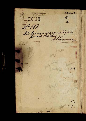
 Joseph Mallord William Turner, Sketch Map of North-West and Central Yorkshire; Executors' Endorsements c.1816 (Inside front cover of sketchbook)Inside front cover of sketchbook
 -
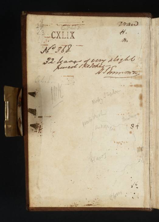
 Joseph Mallord William Turner, Sketch Map of North-West and Central Yorkshire; Executors' Endorsements c.1816 (Enhanced image)Enhanced image
Inside front cover of sketchbook
Joseph Mallord William Turner,
Sketch Map of North-West and Central Yorkshire; Executors' Endorsements
c.1816
(Inside front cover of sketchbook)
Joseph Mallord William Turner 1775–1851
Inside Front Cover:
Sketch Map of North-West and Central Yorkshire; Executors’ Endorsements c.1816
D40859
Pencil on white wove paper, 149 x 93 mm
Inscribed by Turner in pencil with places names, numbers and other data associated with the map (see main catalogue entry)
Endorsed in 1856 by the Executors of the Turner Bequest in ink ‘No. 368 | 32 leaves of very slight | pencil sketches’, signed by Henry Scott Trimmer ‘H S Trimmer’ and initialled in pencil by Charles Lock Eastlake ‘C.L.E.’ and John Prescott Knight ‘JPK’
Inscribed by unknown hand in pencil with Turner Bequest number ‘CXLIX’ towards top and stamped in black ink ‘CXLIX’ top left
Accepted by the nation as part of the Turner Bequest 1856
References
1909
A.J. Finberg, A Complete Inventory of the Drawings of the Turner Bequest, London 1909, vol.I, p.428, as ‘...sketch maps...’.
This is the left half of a double-page spread, continued to the right on folio 1 recto (D11596) opposite, forming a sketch map of north-west and central Yorkshire. On this portion of the map Turner has noted ‘Kirby Stephen’, ‘Worton Park’ (Wharton Hall), ‘Pendragon Castle’, ‘Haws’ (Hawes), ‘?Thorn’ (somewhere south-east of Hawes, possibly Yokenthwaite in Upper Wharfedale) and ‘Muker’ south-east of Pendragon Castle and, below that, ‘Askrigg’ continuing across the gutter of the book to folio 1 (D11596). Turner has also noted what may be distances in miles; in ink ‘8 +’ to right of the map, and in pencil ‘16’ bottom right. A further table, probably also of mileages, is written in pencil at top left:
4
27
23
17
27
23
17
A further inscription at top right reads ‘Draw | H | M’.
Turner passed through Upper Wharfedale, Wensleydale and the lower part of Swaledale on his tour of Yorkshire in 1816. Sketches of subjects in those areas occur in the Yorkshire 2, Yorkshire 4 and Yorkshire 5 sketchbooks (Tate D11042–D11371; D40844–D40845; D41443; Turner Bequest CXLV; Tate D11442–D11479; D11481–D11517; D40839–D40843; D41497; Turner Bequest CXLVII; Tate D11518–D11595; D40860–D40862; Turner Bequest CXLVIII). On that occasion he did not, however, visit the Upper Eden Valley or Upper Swaledale, both of which are marked on this map, and indeed there is no evidence that he ever visited those areas. We might surmise that the sketch map was made as preparation for the tour of 1816, but that in the event he changed his plans.
David Hill
October 2008
How to cite
David Hill, ‘Sketch Map of North-West and Central Yorkshire; Executors’ Endorsements c.1816 by Joseph Mallord William Turner’, catalogue entry, October 2008, in David Blayney Brown (ed.), J.M.W. Turner: Sketchbooks, Drawings and Watercolours, Tate Research Publication, December 2013, https://www

