Joseph Mallord William Turner Stirling from the North-East 1831
Image 1 of 2
Joseph Mallord William Turner,
Stirling from the North-East
1831
Joseph Mallord William Turner 1775–1851
Folio 12 Verso:
Stirling from the North-East 1831
D26459
Turner Bequest CCLXX 12a
Turner Bequest CCLXX 12a
Pencil on white wove paper, 125 x 201 mm
Inscribed in pencil by Turner ‘Sheriffmuir’ bottom right of upper sketch, ?‘Limekiln’ centre of lower sketch, ‘Bdg of allan’ bottom, ‘corn’ bottom centre right, ?‘Red [...]’ [or ‘Road B’] bottom right
Inscribed in pencil by Turner ‘Sheriffmuir’ bottom right of upper sketch, ?‘Limekiln’ centre of lower sketch, ‘Bdg of allan’ bottom, ‘corn’ bottom centre right, ?‘Red [...]’ [or ‘Road B’] bottom right
Accepted by the nation as part of the Turner Bequest 1856
References
1909
A.J. Finberg, A Complete Inventory of the Drawings of the Turner Bequest, London 1909, vol.II, p.868, CCLXX 12a, as “Sheriffmuir.”.
1936
Henry J. Crawford, Turner’s Sketches and Drawings of Stirling and Neighbourhood With Some Notes on the Artist’s Scottish Tours also A Note on John Ruskin and Stirling, Stirling 1936, p.22.
1990
Dr David Wallace-Hadrill and Janet Carolan, ‘Turner’s Sketches North of Stirling’, Turner Studies: His Art and Epoch 1775 – 1851, Summer 1990, vol.10 no.1, p.17.
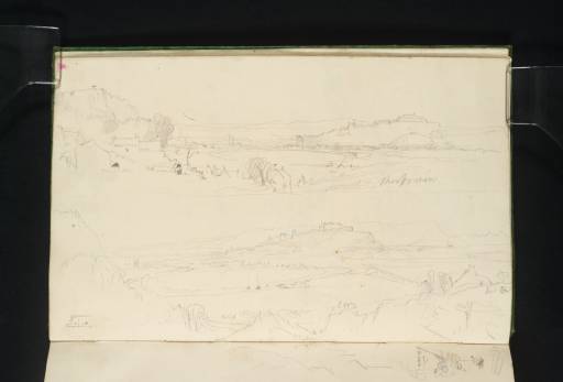
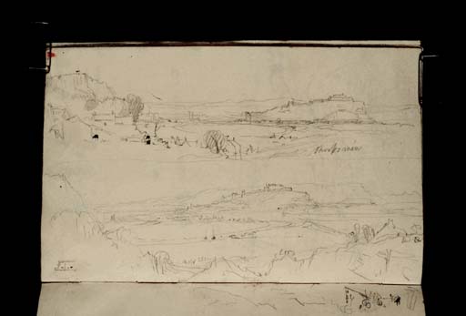
These two views of Stirling were made from the north-east. At the top is a view from just west of Abbey Craig on the road to the Bridge of Allan. Abbey Craig frames the left side of the picture and Castle Rock with Stirling Castle is at the centre right, with a twist of the River Forth in the middle distance. Cambuskenneth Tower, which is also sketched at the bottom left of the page with the book turned to the left, can be seen to the left of the castle. This sketch is inscribed ‘Sheriffmuir’, which Finberg followed in his title.1 However, H.J. Crawford has argued that Turner must have been referring to the farm of Sherifmuirlands (originally Chirmerlands) in the foreground, rather than the battlefield of Sheriffmuir which lies four or five miles to the north near Dunblane.2
Across the bottom half of the page is a similar view, though this time from slightly to the east, perhaps from the lower slopes of Abbey Craig. The shoulder of rock at the left is very similar to the foreground of the sketch on folio 13 (D26460), which was used as the basis for Turner’s watercolour of Stirling circa 1834–5 (Glasgow Museums)3 engraved for Tales of a Grandfather, volume 23 of Sir Walter Scott’s Prose Works, published in 1836. In fact, although the foreground of folio 13 is very close to the watercolour, several elements of the view beyond contributed to the design. The most obvious similarity is in the placement of Castle Rock which appears in the centre of this sketch. While it is further to the right on folio 13, the hills beyond the rock were also copied in the design. Turner also based the shape of the river and the two boats upon it on this sketch. The sketch is inscribed is several places. Along the river just below the castle is an inscription that may read ‘Limekiln’, suggesting that Turner saw a lime kiln on the shore of the Forth. At the bottom of the page Turner wrote ‘Bdg of allan’, indicating the road to Bridge of Allan, rather than the village itself which is further north. David Wallace-Hadrill and Janet Carolan have read the inscription ‘Corn’ to the lower centre right of the sketch as a reference to the district of Cornton which lies between Bridge of Allan and Stirling,4 although Turner included a figure cutting corn in his watercolour of Stirling, raising this as another possibility. At the bottom right of the sketch is an inscription that may refer to a ‘Red R[oof]’ or perhaps a ‘Road B[ridge]’. The roof that appears at this point in the sketch was also incorporated into the watercolour design.
For more information on Turner’s visit to Stirling and references to further sketches see folio 13.
Thomas Ardill
June 2010
How to cite
Thomas Ardill, ‘Stirling from the North-East 1831 by Joseph Mallord William Turner’, catalogue entry, June 2010, in David Blayney Brown (ed.), J.M.W. Turner: Sketchbooks, Drawings and Watercolours, Tate Research Publication, December 2012, https://www


