Joseph Mallord William Turner The Pont Royal, Paris, from the Quai des Tuileries; and Part of the ?Pont de la Concorde 1819
Image 1 of 2
Joseph Mallord William Turner,
The Pont Royal, Paris, from the Quai des Tuileries; and Part of the ?Pont de la Concorde
1819
Joseph Mallord William Turner 1775–1851
Folio 2 Recto:
The Pont Royal, Paris, from the Quai des Tuileries; and Part of the ?Pont de la Concorde 1819
D13993
Turner Bequest CLXXIII 2
Turner Bequest CLXXIII 2
Pencil on white wove paper, 114 x 185 mm
Stamped in black ‘CLXXIII 2’ bottom right
Accepted by the nation as part of the Turner Bequest 1856
References
1909
A.J. Finberg, A Complete Inventory of the Drawings of the Turner Bequest, London 1909, vol.I, p.503, as ‘Bridge and quays’.
1981
Maurice Guillaud, Nicholas Alfrey, Andrew Wilton and others, Turner en France: aquarelles, peintures, dessins, gravures, carnets de croquis / Turner in France: Watercolours, Paintings, Drawings, Engravings, Sketchbooks, exhibition catalogue, Centre Culturel du Marais, Paris 1981, p.106, reproduced fig.169, as ‘Panthéon, St-Germain-des-Prés, quai des Tuileries, Louvre à gauche’.
1999
Ian Warrell, Turner on the Seine, exhibition catalogue, Tate Gallery, London 1999, p.18.
Aside from a single drawing at Beauvais, the first time Turner had the opportunity or inclination to use his sketchbook on his 1819 tour was in Paris where he broke his journey for at least a day and made a series of topographical sketches.1 Although he had first visited the French capital in 1802, on this occasion he had concentrated solely on artistic subjects, primarily Old Master paintings in the Louvre (see the Studies in the Louvre sketchbook, Tate, Turner Bequest LXXII). The 1819 views therefore represent his first on-the-spot studies of the city’s streets and buildings, and also his first response to the River Seine which would become an important theme during the 1830s. The Parisian sketches can be found between folios 2–14 (D13993–D14013), and record an ordered and logical sequence of movements. Turner first made several studies in the centre of the city, concentrating solely on the right bank of the river as far as the Barrière des Bonhommes at Passy. He then took a short expedition south-west to Sèvres and St-Cloud in the outskirts of the city, before returning and back to Passy again. This sequence, however, is interspersed with a second and unrelated set of drawings depicting mountains, probably relating to the journey through Savoy, see folio 2 verso (D13994).
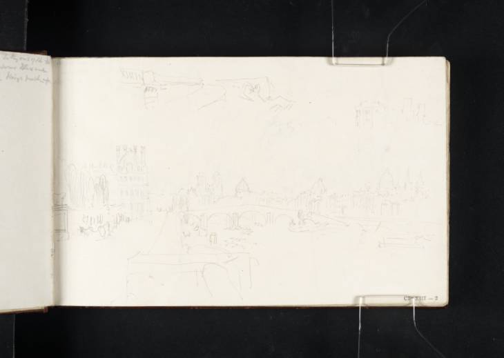
This page contains two distinct drawings in three component parts. The main vista is taken from the Quai des Tuileries on the right bank of the Seine at a point alongside the Tuileries Gardens, and looks up-river (east) towards the Pont Royal.2 The view encompasses a number of notable Parisian landmarks, including from left to right: the Pavillon de Flore (part of the Louvre dating from the sixteenth century which stands near the northern end of the Pont Royal); the towers of the Cathedral of Notre-Dame; and the dome of the Institut de France (directly above the central arch of the bridge); the dome of the Panthéon; and the tower of the Abbey of St-Germain-des Prés (far right-hand side). Turner appears to have continued the line of the buildings on the right-hand side of the composition by extending the view within the top right-hand corner of the sheet. This way of surveying the architectural sweep of the city from the banks of the river was an approach which Turner would adopt when sketching many of the larger Italian cities such as Turin, Florence and Rome. Former Tate curator and Turner expert Ian Warrell has described it as creating ‘openness and the sense of stately progress lined by fine architecture.’3
Also on the page is a smaller study in the top left-hand corner which appears to depict one end of a bridge. The drawing is rather rough and incomplete but the structure appears to include a balustrade and therefore may possibly represent the Pont de la Concorde, built at the end of the eighteenth century.
Nicola Moorby
February 2013
How to cite
Nicola Moorby, ‘The Pont Royal, Paris, from the Quai des Tuileries; and Part of the ?Pont de la Concorde 1819 by Joseph Mallord William Turner’, catalogue entry, February 2013, in David Blayney Brown (ed.), J.M.W. Turner: Sketchbooks, Drawings and Watercolours, Tate Research Publication, August 2013, https://www


