Joseph Mallord William Turner Views of the French Coast c.1821-2
Image 1 of 2
Joseph Mallord William Turner,
Views of the French Coast
c.1821-2
Joseph Mallord William Turner 1775–1851
Folio 78 Verso:
Views of the French Coast c.1821–2
D17340
Turner Bequest CXCVIII 78a
Turner Bequest CXCVIII 78a
Pencil on white wove paper, 187 x 113 mm
Partial watermark ‘T Edm | 18’
Inscribed by Turner in pencil ‘Cliff’ top towards centre, ‘SEbE’ above and right of centre, ‘ENE’ right of centre, ‘SSW’ below and right of centre
Partial watermark ‘T Edm | 18’
Inscribed by Turner in pencil ‘Cliff’ top towards centre, ‘SEbE’ above and right of centre, ‘ENE’ right of centre, ‘SSW’ below and right of centre
Accepted by the nation as part of the Turner Bequest 1856
References
1909
A.J. Finberg, A Complete Inventory of the Drawings of the Turner Bequest, London 1909, vol.I, p.606, CXCVIII 78a, as ‘Views of French coast, from the Channel. “Cliff,” “S.E.I.E.,” “E.N.E.,” “S.S.W.”’.
This page is packed with illustrations taken from The Little Sea Torch, an illustrated maritime text by Richard Bougard, translated from the French by J.T. Serres and published in London in 1801.1 For more detailed information about the publication, and an interrogation of Turner’s use of it, see the sketchbook Introduction. For a comprehensive list of the other pages in this sketchbook used for the same purpose, see the entry for folio 55 recto (D17296).
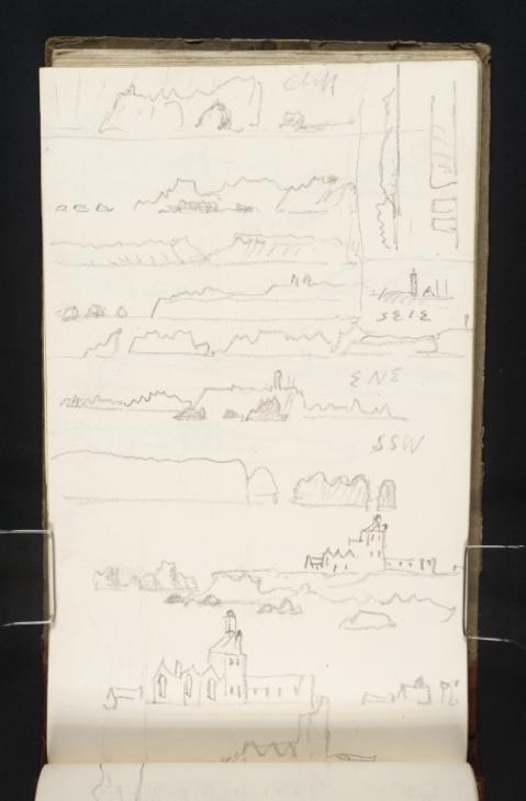
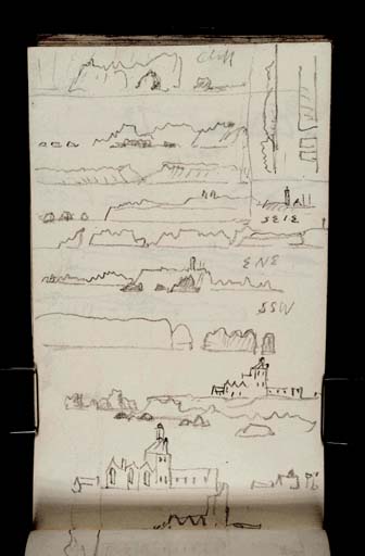
All of the drawings on this page come from plate 2 of The Little Sea Torch.2 As per Finberg’s identification, they present views of the French coast.3 Beginning with those made with the sketchbook turned vertically, Turner starts at the top with a rendering of ‘Toulinguet Rock near Brest’, also the first engraving from this second plate.4 Pointe du Toulinguet is situated at the end of a peninsula at Camaret-sur-Mer in northwest France. Turner transcribes the engraving faithfully, describing a distinctive rock at Pointe du Toulinguet with a hollow archway cutting through it. He inscribes the word ‘Cliff’ at top right to indicate the cliff face that looms up behind this rock in the original illustration. The sketch is separated off from the rest of the page by a single horizontal pencil line.
Second from top is a copy of an illustration of ‘Conquet Pt.’ and ‘St. Matthews Pt’.5 Le Conquet is in Brittany, northwest France. It lies very close to Pointe St-Mathieu, and between the two headlands are the ruins of an extensive medieval monastery where monks used to keep a fire to warn passing ships of the treacherous waters.6 Turner captures the distinctive flat mound at Le Conquet, and marks in his sketch the row of three rocks out at sea towards the left, which demonstrate the threat to sailors attempting to navigate the shallows.
Immediately following Le Conquet is Turner’s copy of ‘Cameret Bay’, the third engraving on plate 2.7 Camaret Bay is a small inlet on the north coast of Brittany, at Camaret-sur-Mer. Turner transcribes the topography as it appears in The Little Sea Torch, which amounts to two rocky headlands overlapping towards the centre.
Immediately following Le Conquet is Turner’s copy of ‘Cameret Bay’, the third engraving on plate 2.7 Camaret Bay is a small inlet on the north coast of Brittany, at Camaret-sur-Mer. Turner transcribes the topography as it appears in The Little Sea Torch, which amounts to two rocky headlands overlapping towards the centre.
Working sequentially through the printed engravings, next Turner tackles ‘The Lizard’, a peninsula in Cornwall.8 Three rocks mark the left edge of both the illustration and Turner’s sketch, and at right on the mainland is the distinctive outline of the lighthouse in operation there.Earlier in the present sketchbook are two additional studies of the Lizard, both also taken from The Little Sea Torch. For information about these, see the entry for folio 55 verso (D17297).
On the right, adjacent with the drawing of The Lizard, is a detail of a lighthouse and surrounding outbuildings. This relates to a full-width sketch below of an illustration titled ‘Ushant S.E.bE.’9 The lighthouse is likely to be Le Stiff, a beacon on the Isle of Ushant which dates from 1699.10Turner makes additional copies from illustrations of Ushant in The Little Sea Torch on folio 56 recto of this sketchbook (D17298). For more information about these drawings, and the location with which they are concerned, see the entry for that page.
Next, at right of centre, is the pencil inscription ‘ENE’, which relates to the sketch directly beneath. This describes another view of Ushant taken from plate 2 of The Little Sea Torch, this time from an east north-easterly direction, the point on a compass halfway between due east and northeast, 67°30' eastof due north.11
Beneath this is an additional compass-point inscription at far right: ‘SSW’, for south-southwest, the point halfway between due south and southeast, 157°30' east of due north. It relates to a drawing of ‘Bec du Raz’ made in the space below, which is once again taken from plate 2 of The Little Sea Torch.12 Pointe du Raz is the most westerly point of France, again situated in Brittany. It became a popular tourist destination in the nineteenth century after featuring in the prose of writers such as Gustave Flaubert and Victor Hugo who found inspiration in its striking topography.13 Here, as illustrated by the engraving and thus in Turner’s interpretation, great lumps of rock stand in isolation at the end of the peninsula on the right, jutting out from a steely grey sea. Turner differentiates these stony projections from the mainland in technique as well as composition, shading them with hatched lines to achieve a dark impression.
The rest of the page is dedicated to iterations of ‘The Ruins of the Monastery of St. Matthews converted into a Lighthouse, bearing N.¾W’.14 The original illustration in The Little Sea Torch demonstrates a picturesque panorama of the defunct monastery, with smoke billowing from a fire at the centre of the image and the rocky end of the headland petering off at left. The building is described in some detail compared with others featured on this page. Each window is delineated and attention is paid to the direction at which the sun strikes the walls. Echoing this care in rendering the architecture, Turner takes some pains to record its forms. He repeats his drawing thrice in this bottom section of the page. The first includes some of the rocky topography and explores a basic outline of the main monastery building, omitting almost everything to the right of it in the original picture. Windows are marked in this example by simple lines, but the shapes of the various roofs are identified and the overall effect is of interest in the presence of the building in relation to its coastal surroundings.
The second of these renderings of the monastery concentrates solely on the architecture, stripping the scene of its topographic characteristics. The outbuildings at right are reintroduced, and the windows and chimney of the main structure are elaborated more fully. At the extreme bottom of the page, almost at the gutter, a very rough sketch of the main building is repeated, reduced to simple lines and stripped of any detail.
Finally, in the top right corner and made with the sketchbook oriented as per its foliation, are two additional sketches copied from The Little Sea Torch. Stacked one on top of the other, the first is taken from engraving ‘10’ on plate 2, ‘Cape Prior E.b.N’.15 Turner records in miniature the topographic shapes indicated in the illustration, which broadly speaking splits the landscape into three sections. Beneath this is a drawing of ‘Old Harry, Studland Bay’.16 Turner makes another sketch of these distinctive chalk rocks off Handfast Point in Dorset on folio 57 recto (D17300), taken from another plate in the same printed source. 17
Maud Whatley
January 2016
Richard Bougard, The Little Sea Torch: or, True Guide for Coasting Pilots: by which they are clearly instructed how to navigate along the coasts of Malta, Corsica, Sardinia, and others in the Straits; and of The Coast of Barbary, from Cape Bon to Cape de Verd, trans. with corrections and additions by John Thomas Serres, London 1801. For an online and PDF facsimile, see ‘The Little Sea Torch’, Biblioteca Nacional de Portugal, accessed 26 October 2015, http://purl.pt/23500 .
‘Plate 2’, The Little Sea Torch, accessed 18 November 2015, http://purl.pt/23500/1/index.html#/153/html .
‘Pointe St-Mathieu and Le Conquet’, Tourisme Bretagne, accessed 18 November 2015, http://www.brittanytourism.com/discover-our-destinations/brest-terres-oceanes/unmissable-sites/pointe-st-mathieu-and-le-conquet .
‘Lighthouses of Northern France’, The University of North Carolina, accessed 3 November 2015, https://www.unc.edu/~rowlett/lighthouse/fns.htm .
‘Pointe du Raz and the Cap Sizun’, Tourisme Bretagne, accessed 18 November 2015, http://www.brittanytourism.com/discover-our-destinations/quimper-cornouaille/unmissable-sites/pointe-du-raz-and-the-cap-sizun .
‘Old Harry Rocks’, Jurassic Coast: Dorset and East Devon World Heritage Site, accessed 6 November 2015, http://jurassiccoast.org/rocks-and-fossils/the-science-of-a-beautiful-landscape/1014-old-harry-rocks .
How to cite
Maud Whatley, ‘Views of the French Coast c.1821–2 by Joseph Mallord William Turner’, catalogue entry, January 2016, in David Blayney Brown (ed.), J.M.W. Turner: Sketchbooks, Drawings and Watercolours, Tate Research Publication, February 2017, https://www


