Joseph Mallord William Turner View of Tivoli from the Summit of Monte Catillo 1819
Image 1 of 2
Joseph Mallord William Turner,
View of Tivoli from the Summit of Monte Catillo
1819
Joseph Mallord William Turner 1775–1851
Folio 31 Recto:
View of Tivoli from the Summit of Monte Catillo 1819
D16119
Turner Bequest CLXXXVII 31
Turner Bequest CLXXXVII 31
Pencil on white wove paper, 255 x 403 mm
Inscribed by John Ruskin in blue ink ‘31’ bottom right, descending right-hand edge
Stamped in black ‘CLXXXVII 31’ bottom right
Inscribed by John Ruskin in blue ink ‘31’ bottom right, descending right-hand edge
Stamped in black ‘CLXXXVII 31’ bottom right
Accepted by the nation as part of the Turner Bequest 1856
References
1909
A.J. Finberg, A Complete Inventory of the Drawings of the Turner Bequest, London 1909, vol.I, p.556, as ‘Tivoli’.
1914
Thomas Ashby, ‘Turner at Tivoli’, Burlington Magazine, vol.25, no.136, July 1914, p.242, reproduced pl.I.A, as ‘View from the Summit of Monte Catillo’.
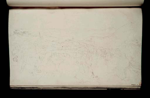
As Thomas Ashby first identified, this drawing represents a general view of Tivoli from the summit of Monte Catillo to the east.1 The arch visible near the central foreground is the medieval gate of Porta Cornuta, now no longer extant. Beyond this the River Aniene winds through the town on its former course, before plunging as the ‘Grand Cascade’ at a point near the so-called Temple of Vesta on the right. After a devastating flood in 1826 the river was diverted in underground tunnels away from the residential district, altering the site of the waterfall. The key buildings silhouetted along the top of the town however, can all still be seen. These include, from left to right: the Rocca Pia, Tivoli’s fifteenth-century fortress; the campanile of Santa Maria Maggiore, the church adjacent to the Villa d’Este; the campanile of the Cathedral (Duomo) of San Lorenzo; and a medieval watch-tower which stands above the cascatelli (or cascatelle), the lesser cascades to the north. On the slopes of the opposite side of the valley is the long, low building of the Convent of San Antonio, also known as the Villa d’Orazio (Villa of Horace).2 In the distance to the west, the river meanders through the flat plain of the Campagna, and just visible on the far horizon is the dome of St Peter’s in Rome. On the far right side are the three conical peaks known as the Montes Corniculani (Horned Mountains), crowned by the villages of Montecelio and Sant’Angelo Romano. Similar studies can be found in the Tivoli and Rome sketchbook (Tate D15080; Turner Bequest CLXXIX 80a) and in the Tivoli sketchbook (Tate D15554; Turner Bequest CLXXXIII 82).
Unlike the watercolour or tonal studies on grey watercolour wash elsewhere in this sketchbook, Turner’s focus here is the exact mapping of Tivoli’s topography with no indication of naturalistic or atmospheric effects. Thomas Ashby confirmed the accuracy of the prospect including the ‘rendering of the straggling line of the modern high road to Rome, and on the extreme left the dark spot which shows us the tower of Castiglione, marking the citadel of Gabii’.3 In the left-hand foreground, the figure of a man sits surveying the prospect spread out before him.
Verso:
Blank, save for inscription by an unknown hand in pencil ‘[?M]’ bottom right, ascending right-hand edge.
Nicola Moorby
March 2010
How to cite
Nicola Moorby, ‘View of Tivoli from the Summit of Monte Catillo 1819 by Joseph Mallord William Turner’, catalogue entry, March 2010, in David Blayney Brown (ed.), J.M.W. Turner: Sketchbooks, Drawings and Watercolours, Tate Research Publication, December 2012, https://www


