J.M.W. Turner: Sketchbooks, Drawings and Watercolours

ISBN 978-1-84976-386-8

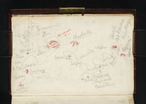
Joseph Mallord William Turner Sketch Map of the Meuse between Sedan and Fumay 1824

Joseph Mallord William Turner 1775–1851
Folio 1 Verso:
Sketch Map of the Meuse between Sedan and Fumay 1824
D19553
Turner Bequest CCXVI 1 a
Pencil and pen and red and blue ink on white wove paper, 78 x 118 mm
Inscribed in pencil and pen and red and blue ink by Turner (see main catalogue entry)
 
Accepted by the nation as part of the Turner Bequest 1856
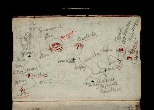
Here Turner continues the sketch map of the Meuse from the previous two folios (Tate D40727, D19552; Turner Bequest CCXVI 1). The route follows the river across the Ardennes department of north-eastern France from the town of Sedan to Fumay.
From Sedan (bottom left), Turner lists: ‘Fresnay’ (Frénois); ‘Donchery’; ‘Nouvion’ (Nouvion-sur-Meuse); ‘R Bar’ (Pont à Bar); ‘Don’ (Dom-le-Mesnil); ‘?Ellain’ (?Chalandry-Elaire); ‘?Fluze’ (Flize); ‘Villers’ (Villers-Semeuse); ‘Varmmecourt’ (Warnècourt); ‘Pris’ (Prix-Lès-Mézières); ‘Miezire’ (Mézières); ‘Charleville’; ‘Nouranville’ (Nouzonville); ‘[Warridon]’; ‘Joigny’ (Joigny-sur-Meuse); ‘Thilay’; ‘Chataux | Reynault’ (Château Reynault); ‘Bouillin’ (?Bogny-sur-Meuse); ‘Montherm’ (Monthermé); ‘?Dile’ (Deville); ‘Ancham’ (Anchamps); ‘Latour’ (Laifour); ‘Revin’; ‘Forest Ardennes | R La Vergine’; ‘Fumai’ | ‘Exp[...]’.

Alice Rylance-Watson
January 2014

How to cite

Alice Rylance-Watson, ‘Sketch Map of the Meuse between Sedan and Fumay 1824 by Joseph Mallord William Turner’, catalogue entry, January 2014, in David Blayney Brown (ed.), J.M.W. Turner: Sketchbooks, Drawings and Watercolours, Tate Research Publication, April 2015, https://www.tate.org.uk/art/research-publications/jmw-turner/joseph-mallord-william-turner-sketch-map-of-the-meuse-between-sedan-and-fumay-r1174341, accessed 26 April 2024.