Joseph Mallord William Turner Sketch Map of the Meuse between Givet and Dinant; Part of a Fort 1824
Image 1 of 2
Joseph Mallord William Turner,
Sketch Map of the Meuse between Givet and Dinant; Part of a Fort
1824
Joseph Mallord William Turner 1775–1851
Folio 2 Recto:
Sketch Map of the Meuse between Givet and Dinant; Part of a Fort 1824
D19554
Turner Bequest CCXVI 2
Turner Bequest CCXVI 2
Pencil and pen and red ink on white wove paper, 78 x 118 mm
Inscribed in pencil and pen and red ink by Turner
Inscribed in blue ink by Ruskin ‘2’ top right
Stamped in black ‘CCXVI–2’ bottom right
Inscribed in pencil and pen and red ink by Turner
Inscribed in blue ink by Ruskin ‘2’ top right
Stamped in black ‘CCXVI–2’ bottom right
Accepted by the nation as part of the Turner Bequest 1856
References
1909
A.J. Finberg, A Complete Inventory of the Drawings of the Turner Bequest, London 1909, vol.II, p.666, as ‘Sketch of town, with river beyond; also sketch plan R. Meuse between Dinant and Givet.
1978
Agnes von der Borch, Studien zu Joseph Mallord William Turners Rheinreisen (1817–1844) (Ph.D. thesis, Rheinischen Friedrich-Wilhelms-Universität, Bonn 1972), Bonn 1978, pp.61–2.
1991
Cecilia Powell, Turner’s Rivers of Europe: The Rhine, Meuse and Mosel, exhibition catalogue, Tate Gallery, London 1991, p.37 note 1, [p.60].
1995
Cecilia Powell, Turner in Germany, exhibition catalogue, Tate Gallery, London 1995, p.30 note 4, [p.77].
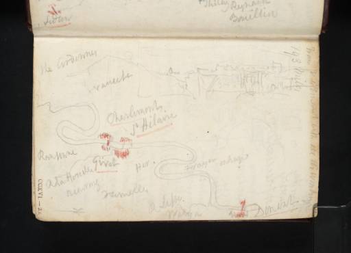
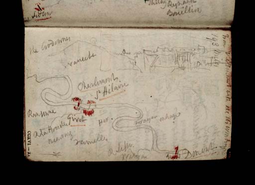
Here Turner has drawn a sketch map of the route of the Meuse between the French border town of Givet and Dinant, in the Walloon region of Belgium.
The ‘Ardennes’, marked out by Turner at top left, is a territory of forests, hills and mountains which begins around France’s frontier with Belgium and stretches east across Luxembourg and Germany. Givet, underlined by Turner in red ink, is the home of the mighty Fort Charlemont, a citadel built by Charles V in the sixteenth century to defend the Meuse valley.1 Turner’s inscriptions ‘Charlemont’ and ‘St Hilaire’, then, account for this fortress and the equally austere and fortress-like Eglise Saint-Hilaire on the left bank of the Meuse.2 It is also likely that the small sketch of a fort at top right shows Charlemont. Drawings of Givet and its monuments are found in both this, the Rivers Meuse and Moselle sketchbook and the Huy and Dinant sketchbook (Tate D19664–D19971, D20114; Turner Bequest CCXVI 57a–61, CCXVII 20).
Surrounding Givet, the towns of Rancennes (‘Ransenne’), Beauraing (‘Beauring’), and Heer (‘Her’) are noted; and, moving towards Dinant, Turner marks out the villages of Freÿr (‘Frayer’), ‘Onhaye’, Pont à Lesse (‘P Lesse’) and ‘Walzin’.
With the sketchbook orientated in accordance with the foliation, Turner has made note of the distance between Verdun, in France, to Dinant; his inscription reads: ‘From V. to Dinant with all its windings 193 miles’.
Alice Rylance-Watson
January 2014
‘Restauration du Christ d’A. Rivoulon de ‘léglise Saint-Hilaire de Givet (Ardennes), DRAC Champagne-Ardennes, accessed 29 January 2014, http://www.culture.gouv.fr/champagne-ardenne/3documentation/nav2_givet.html
How to cite
Alice Rylance-Watson, ‘Sketch Map of the Meuse between Givet and Dinant; Part of a Fort 1824 by Joseph Mallord William Turner’, catalogue entry, January 2014, in David Blayney Brown (ed.), J.M.W. Turner: Sketchbooks, Drawings and Watercolours, Tate Research Publication, April 2015, https://www


