J.M.W. Turner
Joseph Mallord William Turner Headland Views in Devon and France c.1821-2
Image 1 of 2
-
 Joseph Mallord William Turner, Headland Views in Devon and France c.1821-2
 -

") Joseph Mallord William Turner, Headland Views in Devon and France c.1821-2 (Enhanced image)Enhanced image
Joseph Mallord William Turner, Headland Views in Devon and France c.1821-2 (Enhanced image)Enhanced image

Joseph Mallord William Turner,
Headland Views in Devon and France
c.1821-2
Joseph Mallord William Turner 1775–1851
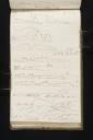
Folio 56 Recto:
Headland Views in Devon and France c.1821–2
D17298
Turner Bequest CXCVIII 56
Turner Bequest CXCVIII 56
Pencil on white wove paper, 187 x 113 mm
Inscribed by Turner in pencil ‘Praul and start’ across top, ‘ENE’ top right, ‘SSE Ushant’ towards centre to the right, ‘start W’ towards bottom left, ‘WSW’ towards centre bottom
Inscribed by John Ruskin in red ink ‘56’ bottom right, descending vertically
Stamped in black ‘CXCVIII – 56’ bottom right, descending vertically
Accepted by the nation as part of the Turner Bequest 1856
References
1909
A.J. Finberg, A Complete Inventory of the Drawings of the Turner Bequest, London 1909, vol.I, p.605, CXCVIII 56, as ‘Views of English and French coast, from the Channel – “Cantifer” (Cap d’Antifer), “Cape Antonio,” “Stromboli” (?), “Lizard. N. W.,” “N.E.,” “Rame Head (?),” “Anchor or Mavigassy Bay” (Mevagissy, in Cornwall), “Prawle and Start” (Points), “E.N.E.,” “S.S.E. Ushant,” “Start Point,” “W.S.W.”’.
1975
Gerald Wilkinson, Turner’s Colour Sketches 1820–34, London 1975, p.22, reproduced.
Leading on from the facing page on folio 55 verso (D17297), here Turner continues a list of tightly packed sketches of headland topography. Made with the sketchbook turned vertically, and with the gutter at the top, these drawings are copied from The Little Sea Torch, an illustrated maritime text by Richard Bougard, translated from the French by J.T. Serres and published in London in 1801.1 Turner has transcribed pictures from this book onto nine pages in the current sketchbook. For a full list of these, see the entry for Folio 55 recto (D17296). For more detailed information about the 1801 publication, and an interrogation of Turner’s use of it, see the sketchbook Introduction.
At the top of this page, almost swallowed by the gutter in places, is the inscription ‘Praul and Start’, followed by ‘ENE’ in the top right corner. ‘Praul’ refers to Prawle Point in south west Devon. In his entry for the page, Finberg corrects Turner’s misspelling.2 In fact, the mistake was inherited from The Little Sea Torch, in the title given to the second engraving on plate 14, the source of Turner’s rendering: ‘Praul Point, & the Start, E.N.E., 2 or 3 Miles dist’.3 ‘Start’ refers to Start Point, also in Devon, which marks the most southern limit of Start Bay. ‘ENE’ means ‘East-northeast’, and refers to the mid-point on a compass between due east and northeast, or 67° 30' clockwise from north.
This first drawing on the page faithfully transcribes the printed reference diagram of Prawle and Start points. The identification is doubly confirmed by the distinctive Horse’s Head rock at the tip of the peninsula on the left. Turner’s pencil is soft but the lines are sharp in places, particularly where the sketch describes the treacherous lip of the cliff top. A second drawing beneath the first repeats the same subject matter, emulating engraving 4 on plate 14 of The Little Sea Torch, entitled ‘Praul Point, E.N.E. 1 Mile dist’.4 Again, the Horse’s Head at Prawle Point forms a distinctive feature on the right hand side, towards the centre of Turner’s page.
The third sketch from the top of this sheet is a copy of a further engraving taken from plate 14 of The Little Sea Torch. The original illustration is number 5, with the title ‘S.E. end of Gaspey, N.W. 3 or 4 Leagues dist’.5 Turner describes each of the two rocky formations on the left with a mostly unbroken line, producing a brief summary of their strikingly symmetrical shapes. Far off to the right, a small oblong of rock sits isolated from the others.
Immediately following the drawing described above is another of Turner’s inscriptions on the far right: ‘SSE Ushant’, as identified by Finberg.6 ‘SSE’ denotes ‘South-southeast’, the compass point midway between south and southeast, or 157°30' east of due north. Ushant is an island at the most westerly point of France, regarded as the entrance to the English Channel.7 It is about 5 miles long and 2 miles wide, with an area of 6 square miles.8 The terrain is extremely rocky, the tides notoriously turbulent; in the words of the Brittany Tourist Board, Ushant has a ‘treacherous seafaring heritage’.9 Today, Ushant is crowded with lighthouses. Most of these were erected throughout the nineteenth and twentieth centuries; however the island is also home to Le Stiff, a beacon which dates from 1699.10 The Le Stiff lighthouse is the second oldest example in France, and stands at 105 feet tall on the eastern edge of Ushant.11 This structure seems to be visible in several of the drawings on this page.
The five sketches beneath the ‘SSE Ushant’ inscription depict the same location from a series of different viewpoints, and are all copied from plate 15 of The Little Sea Torch.12 Turner transcribes the diagrams in the order in which they appear in the printed book, but omits the inscriptions which describe the viewpoints from all but the first (These are, respectively, ‘Ushant S.S.E.’, ‘S.EbS’, ‘S.E.’, ‘S.EbE.’, and ‘E.S.E.’).13 The topography is consistently fragmented throughout the drawings and the engravings. Turner separates each sketch from the others with clearly demarcated spaces.
The final two drawings on this sheet overlap somewhat, both literally and thematically. The first is inscribed towards the left, ‘Start W’. This indicates a return to the headland in Devon featured at the top of the page: Start Point. Looking westward as per his annotation, Turner briefly describes the exposed peninsula as it juts out into the water and gives way to a smattering of semi-submerged rocks in the shallows. On the far right, a foregrounded section of the mainland looms large. Turner extends the line of the cliff face up as far as blank space will allow, completing his present drawing above the earlier sketch. This composition is also copied from plate 15 of The Little Sea Torch, emulating engraving ‘8. The Start, West.’14
The final sketch sits at the very edge of the page, and is inscribed ‘WSW’ at the bottom, towards the left. A repetition of the view of Start Point described above, it is taken from the eighth engraving on plate 15 of The Little Sea Torch.15 Turner apparently transcribes the direction from which it is observed with a degree of inaccuracy, since the original illustration is titled ‘The Start, W.N.W’.16 This drawing is slightly faded and smudged in comparison with its neighbours, a fact likely explained by its proximity to the edge of the well-thumbed page.
Richard Bougard, The Little Sea Torch: or, True Guide for Coasting Pilots: by which they are clearly instructed how to navigate along the coasts of Malta, Corsica, Sardinia, and others in the Straits; and of The Coast of Barbary, from Cape Bon to Cape de Verd, trans. with corrections and additions by John Thomas Serres, London 1801. For an online and PDF facsimile, see ‘The Little Sea Torch’, accessed 26 October 2015, Biblioteca Nacional de Portugal, http://purl.pt/23500 .
‘Plate 14’, accessed 3 November 2015, The Little Sea Torch, http://purl.pt/23500/1/index.html#/177/html .
‘Ushant and the Iroise Islands’, Tourisme Bretagne, accessed 3 November 2015, http://www.brittanytourism.com/discover-our-destinations/brest-terres-oceanes/unmissable-sites/ushant-and-the-iroise-islands .
‘Ouessant Island’, Encyclopaedia Britannica, accessed 3 November 2015, http://www.britannica.com/place/Ouessant-Island .
‘Ushant and the Iroise Islands’, Tourisme Bretagne, accessed 3 November 2015, http://www.brittanytourism.com/discover-our-destinations/brest-terres-oceanes/unmissable-sites/ushant-and-the-iroise-islands .
‘Lighthouses of Northern France’, The University of North Carolina, accessed 3 November 2015, https://www.unc.edu/~rowlett/lighthouse/fns.htm .
Steven Erlanger, ‘France Sees Its Heritage in Its Crumbling Lighthouses’, accessed 3 November 2015, The New York Times, 23 April 2008, http://www.nytimes.com/2008/04/23/world/europe/23lighthouse.html?pagewanted=all&_r=0 .
‘Plate 15’, accessed 3 November 2015, The Little Sea Torch, http://purl.pt/23500/1/index.html#/179/html .
Technical notes:
A very small piece of the page appears to be missing from the bottom edge, towards the right hand corner.
Maud Whatley
January 2016
How to cite
Maud Whatley, ‘Headland Views in Devon and France c.1821–2 by Joseph Mallord William Turner’, catalogue entry, January 2016, in David Blayney Brown (ed.), J.M.W. Turner: Sketchbooks, Drawings and Watercolours, Tate Research Publication, February 2017, https://www