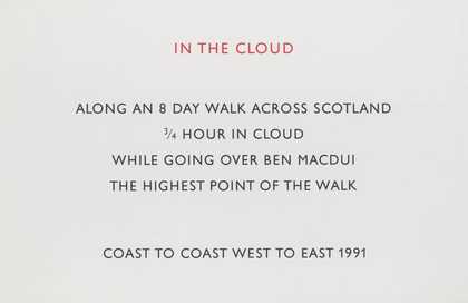
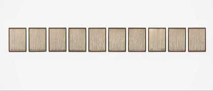
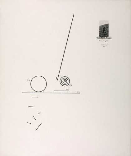
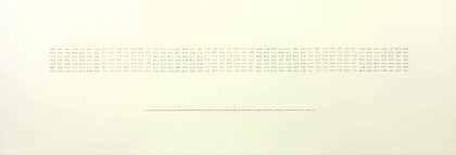
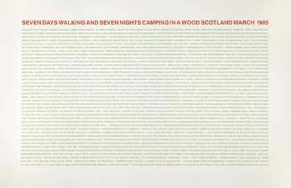
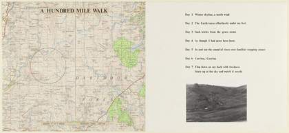
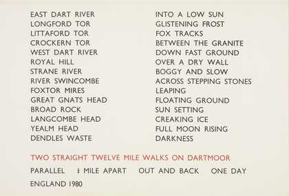
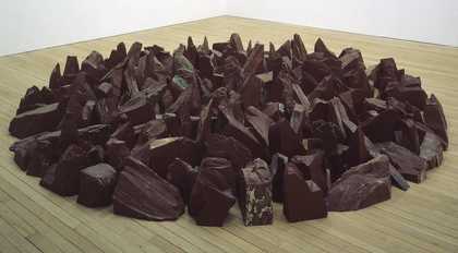
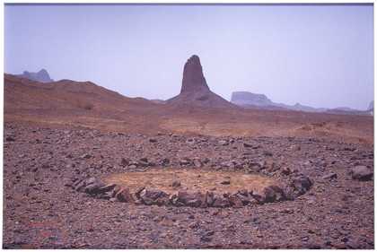
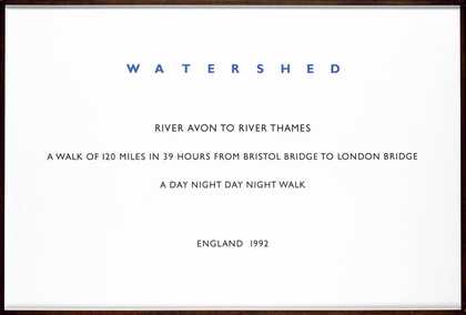
- Artist
- Richard Long CBE born 1945
- Medium
- 3 screenprints on paper on 3 panels
- Dimensions
- Support: 1533 × 1041 mm
support: 1041 × 1533 mm
support: 1041 × 1533 mm - Collection
- Tate
- Acquisition
- Purchased 1988
- Reference
- T05033
Summary
Ten Days Walking and Sleeping on Natural Ground is a text work representing a walk Long made in Scotland over a period of ten days. It comprises three sections of equal size on which text has been printed in brown ink. Each section describes the walk through different aspects. The central panel is vertical and the two flanking panels are horizontal. On the left side the title is printed across the centre of the page. The central panel lists the Gaelic and English names of places and topographical features passed by the artist during his walk above the subtitle ‘A 134 mile meandering walk/ Scotland 1986’. The names and features are listed in a vertical line, one below the next. Some place names from the beginning of the list are repeated in inverse order at its end, indicating that the walk was circular. The panel on the right reproduces the form of the circle with phrases, in apparently random order, describing the artist’s experiences during the walk. These include things seen, heard and smelled as well as actions and observations. Long has explained:
The title was the original idea and everything flowed from that. The walk was to be random and meandering ... It took ten days to complete and I camped the whole time ... I had this particular idea, to make a walk in a wilderness area only on natural ground, without using footpaths ... I chose one particular part of Scotland, in the Highlands. It was off the beaten track, full of mountains and moorland and I particularly chose it because it was almost empty of trails and footpaths ... this work gave me the opportunity to isolate and concentrate on certain aspects of information – both objective, from the map, and subjective, from the walk.
The key to the circular text section is the words at the top [‘mind map’] because it is subjective, and the opposite of the objective naming and chronology of places. It describes ideas, thought and experiences mixed up and floated in time, in a random way ... In this work I also became interested in the idea of using words in a different way. Even though I listed all the places I went through, it is not necessary to understand them. You can read them visually, or see them repeated, see the geographic rhythm, without understanding Gaelic ... I think [words] are an open system to be read with meaning, or no meaning, or any interpretation. But the way I use them, they are first visual images, like all art.
(Quoted in Tate Gallery: Illustrated Catalogue of Acquisitions 1986-88, pp.413-4.)
Long’s first purely text work was a poster created in 1969 for the seminal exhibition of Conceptual art, When Attitudes Become Form: Live in Your Head, curated by Harald Szeemann and held at the Bern Kunsthalle in Switzerland. This poster stated simply his name, the dates of a ten day period, and the description of his action, ‘A Walking Tour in the Berneroberland’, which was the title of the work (whereabouts unknown). He has subsequently distinguished his work from the Conceptual art movement, since for him the execution of the idea is of primary importance, rather than the idea itself. But, like text works created by Conceptual artists, Long’s work requires reading and thinking on the part of the viewer to complete it. Ten Days Walking and Sleeping on Natural Ground transforms the artist’s slow, rhythmic and reflective activity of walking in the outdoor world into the viewer’s concentrated moment of encounter with words in the gallery. In this work text functions both as visual patterning and as description evoking visual imagery from another time and place.
As is standard in Long’s work, the text appears in capital letters, printed in the Gill Sans typeface. Waterlines 1989 (Tate P11266) is another text-only work by Long.
Further reading:
R.H. Fuchs, Richard Long, exhibition catalogue, Solomon R. Guggenheim Museum, New York 1986
Richard Long: Walking in Circles, exhibition catalogue, South Bank Centre, London 1991, reproduced (colour) pp.89-91
Tate Gallery: Illustrated Catalogue of Acquisitions 1986-88, London 1996, pp.413-5, reproduced p.413
Elizabeth Manchester
November 2000/October 2001
Does this text contain inaccurate information or language that you feel we should improve or change? We would like to hear from you.
Catalogue entry
T05033 Ten Days Walking and Sleeping on Natural Ground
1986
Three panels of printed text on wove paper 1041 × 1533 (41 × 60 3/8), 1533 × 1041 (60 3/8 × 41), 1041 × 1533 (41 × 60 3/8); overall size variable
Various printed inscriptions
Purchased from Anthony d'Offay Gallery (Grant-in-Aid) 1988
Repr: Richard Long: Walking in Circles, exh. cat., Hayward Gallery 1991, pp.89–91
This work consists of three panels, described by the artist as sections. The central section has a vertical format; the outer two are horizontal. The left-hand section contains the title of the work printed across the centre. The middle section contains a centred, vertical list of Gaelic and English names of places and topographical features passed by the artist during the course of a 134 mile walk made in Scotland in 1986. In conversation with the compiler on 29 September 1990, the artist said he preferred not to specify the exact route of the walk. The right-hand section contains single words and short phrases which are typographically formed into and contained within a circle. They record Long's observations of the landscape, the weather conditions, the experience of walking, and things heard or smelt (for example, ‘deer tracks’, ‘deep dreaming’, ‘following a map’, ‘full moon touching the horizon’, ‘scent of heather’). All the texts are printed in brown ink. The artist confirmed through the Anthony d'Offay Gallery on 14 January 1988 that T05033 should be hung with the column of place names in the centre, flanked by the text phrases formed into a circle on the right and the title of the work to the left. The artist normally hangs the sections nine inches (228 mm) apart.
The following comments made in conversation with the compiler on 29 September 1990 were edited by the artist in two letters, the first postmarked 17 October 1992 and the second dated 4 February 1994:
The title embodies the idea of the walk and the central section, with the line of names from the top, is actually a chronology of all the different named places I passed through. The title was the original idea and every thing flowed from that. The walk was to be random and meandering. I did not walk a planned mileage, although I do on some of my walks. It took ten days to complete and I camped the whole time. Sometimes I will actually have an idea of the visual presentation that the art will take before I do a walk, although I cannot remember what happened in this case. I had this particular idea, to make a walk in a wilderness area only on natural ground, without using footpaths. There are so many different types of land, after all - and this walk refers to a typical type of landscape: open moorland. there is a lot of that in Scotland. It was high summer, so there were a lot of walking hours each day.
The circularity of the right-hand section was actually reflected in the kind of circularity of the walk itself, which began and ended at the same place. If you pay attention to some of the names, you see on the central section that I started and finished in the same place. So it was an eliptical walk, which I deliberately finished in the reverse order of places that I started.
I chose one particular part of Scotland, in the Highlands. It was off the beaten track, full of mountains and moorland and I particularly chose it because it was almost empty of trails and footpaths. I think, if you pay attention to all the place names, you could find this area in Scotland and that if you pay attention to the [central] section you will find the factual and objective progress of the walk and everything you need to know about the geography of the walk. I did vaguely know the area and I knew that it would service this particular idea for a walk.
I walked with a map, which is typical for some of my walks in the sense that I planned it by looking at maps, whereas other walks can be done without using a map at all. This is a map walk - after all the map provided the place names [on the central section] - but the map did not guide my walk exactly. I needed it overall and at certain times, but I also followed a combination of motives and instincts to determine the direction I walked and there are lots of clues [in the circular text] about the way I went about making the walk. Sometimes I followed a compass, sometimes the line of a river - there are lots of clues. One thing I did notice. Even though I do not speak Gaelic [the language of many of the place names in the central panel], I realised what some of the words mean by doing the walk. Some actually just describe certain places, such as a scree slope or rocky outcrop.
The names in the central section refer to places I passed, in sequence. I used an Ordnance Survey map, but often where I was walking there was ‘nothing’, it was featureless, yet the map was full of names. I find it interesting, thinking about who decides what goes on maps. I think they could be naming places and using words which have long since gone out of use. I often have the feeling that maps are things in their own right, especially wilderness maps. I suppose there is also the point that the way things are named actually determines our understanding and perception of the world. Also, we all have different views of the ‘same’ places, in unrepeatable time, which makes life unique. So this work gave me the opportunity to isolate and concentrate on certain aspects of information - both objective, from the map, and subjective, from the walk.
The key to the circular text section is the words at the top [‘MIND MAP’], because it is subjective, and the opposite of the objective naming and chronology of places. It describes ideas, thoughts and experiences mixed up and floated in time, in a random way. In other words, the ordering of the circular text is like the opposite system to the chronology of the line. Also, the circle of the right hand section actually reflected the kind of circularity of the walk in an alternative way to the place names. In this work I also became interested in the idea of using words in a different way. Even though I listed all the places I went through, it is not necessary to understand them. You can read them visually, or see them repeated, see the geographic rhythm, without understanding Gaelic.
Even though I am using words, I am still using them as an artist, not as a writer. I do not see the words as poetry or literature. I think they are an open system to be read with meaning, or no meaning, or any interpretation. But the way I use them, they are first visual images, like all art.
Long has used texts in his work, alone or in combination with maps or photographs, since the mid-1960s. T05033 is typical of many of his text works with its clear organisation of the text. Several works contain texts organised in circles. Others are structured less conventionally. In ‘Stone Water Sound’, 1990 (repr. Hayward Gallery exh. cat. 1991, pp.138–9), for example, the irregular text layout follows the route Long took and the rivers he crossed between the north and south coast of Wales. T05033 is the only multi-section text work he has made.
Long often uses maps on his walks and included Ordnance Survey maps in some works of the 1960s and 1970s (for example, T02066, ‘Cerne Abbas Walk’, 1975). T05033 does not include topographical maps as part of the work. However, the place names taken from the map Long used on the walk in the central section and his designation of the right-hand section of T05033 as a ‘Mind Map’ show the functional and conceptual importance of maps in his walks and works of art. In 1992, in response to a question from a student, Long wrote a short, unpublished text about maps in his work. A copy was sent to the compiler by Lorcan O'Neill of the Anthony d'Offay Gallery on 11 February 1994:
A map can be used (to make a walk).
A map can be used (to make a work of art).
Maps are useful layers of information. They show geography. They show history. They can be an artistic and poetic combination of image and language.
A map can be an alternative to a pictorial image (i.e. it has a different function) while being a rich and economical image in its own right.
It can be more conceptual [...]
Maps can be read in many different ways.
Maps can be read as a standard and universal language.
They are invented by ‘no-one’ and known by ‘everyone’.
Long has used a Gill Sans typeface for almost as long as he has been making text works. The reason, he wrote in a letter to the compiler dated 4 February 1994, is that ‘it looks good, being simple and classical. I like the fact it's now become standard and continuous, like always using the same camera lens’. The technical processes of typesetting, enlarging and silkscreening are done for Long in Bristol by small local firms with which he has worked before. According to the artist, it is practical to do this part of the work close to his home. In a letter to the compiler dated 4 February 1994, Long described the technical process involved in designing and printing his text works:
First, I get the typesetting done on bromide paper, to see it and check it. (In the old days it was hot metal, now it's done on computer.) Then I decide what size I need it and get it enlarged in sections, photographically, as a positive on clear acetate. Then I cut it up, arrange the layout in lines or sections, as necessary, and stick it down (with magic tape) on one large sheet of clear acetate. I then take this to a local commercial silkscreen printer who makes me a few prints. I choose the best (cleanest) one, then take it to London where it is dry-mounted and framed.
The artist has approved this entry.
Published in:
Tate Gallery: Illustrated Catalogue of Acquisitions 1986-88, London 1996
Explore
- abstraction(8,615)
-
- from recognisable sources(3,634)
-
- landscape(1,191)
- non-representational(6,161)
-
- text(1,043)
- universal concepts(6,387)
-
- environment / nature(315)
- recreational activities(2,836)
-
- walking(144)
- UK countries and regions(24,355)
-
- Scotland(2,977)
- inscriptions(6,664)