The history, discourse and practice of travel offer a new paradigm for considering visual culture, especially landscape imagery. It is perhaps not entirely coincidental that the rise of landscape painting as a distinct and dominant genre of European art from the seventeenth to the nineteenth centuries paralleled the exponential growth of global travel and tourism, geographical exploration and knowledge, and colonial and imperial expansion. In very significant ways, as W.J.T. Mitchell has claimed, landscape as an artistic genre is inextricably tied to the practices and ideologies of empire.1 This in turn suggests that landscape is also intimately linked to related forms of travel; not only imperial travel but also discrete or symbolic customs such as pilgrimage or the Grand Tour, or travels and topographies of the imagination that are predicated on the idea of place and space as intrinsically meaningful rather than transparent or neutral. It also suggests that landscape in itself might, or indeed must, be regarded at some level as a form of representation and therefore imbued with political, social, cultural and ideological significance. Considering art in relation to travel – understood discursively, historically, practically or imaginatively – necessarily entails interdisciplinarity, a productive engagement of visual culture with fields such as historical geography, literature, anthropology, or various branches of history: an engagement already implicit in the conjunction of ‘landscape’ and ‘environment’. Among other things, for example, it enables attention to be drawn to a large body of archival material, from ‘fine’ art to amateur sketches, book illustration, maps and other media, generally overlooked for the purposes of art history or visual culture studies. As a consequence, and perhaps most importantly, the paradigm of travel provides a means of challenging hierarchies of genre, medium, place and iconography, and it facilitates the attachment of value to an artefact other than by reference to notions of quality: a drawing made in the field by an amateur draughtsman at the ‘edge of empire’, for example, might assume a level of importance usually reserved for an exhibited oil painting.
The relationship of art to travel can also be productively filtered through theories of re-enactment, and this essay shall consider, as a case study, imagery made by nineteenth-century travellers to the Pacific that clearly recalls the late eighteenth-century work produced by William Hodges and others on Captain James Cook’s voyages between 1768 and 1780.2 As such, this later body of work – which assumes a particular ideological significance due to its relation to earlier imagery that it attempts to ‘re-enact’ – points to broader methodological possibilities for applying theories of re-enactment to certain types or genres of visual art. Re-enactment especially enables a consideration of performativity in relation to artistic production, which is particularly apt for late eighteenth- and early nineteenth-century British culture, where, for example, the re-enactment of naval battles was a common occurrence on the London stage during the wars against France between 1793 and 1815, and where analogous paintings, such as Mather Brown’s Lord Howe on the Deck of the ‘Queen Charlotte’, 1 June 1794 c.1794 (National Maritime Museum, London), clearly draw upon theatrical practices of lighting and staging.3 Theories of re-enactment are perhaps most applicable to works of visual culture produced as part of a process of travel, for it draws attention to image-making as a temporal process, situated both at a particular historical moment and in a specific environment, and that derives meaning from its relation to other temporal frames and other environments (both historical and anticipated, for example, within the overall frame of a single journey). ‘Re-enacting’ art and travel, therefore, also implies an artistic or aesthetic refraction of an environment through a historical lens. This is especially significant for the genre of landscape as a form of visual representation, which is what this essay shall focus on: re-enacting art and travel in relation to landscape and environment.
Re-enactment has received a great deal of critical and theoretical analysis in recent years.4 This discussion, however, shall specifically refer to the philosopher R.G. Collingwood’s (1889–1943) formulation of the idea of history, that, ‘in order to understand a past human action, the historian must not only discover the thought expressed in it, but must actually re-think or re-enact that thought in his own mind’.5 For Collingwood, the role of the historian must not simply be to describe or chronicle past events in the manner of an inventory, but to understand and interpret them, as would an actor or musician playing a character or piece of music. The idea of history as being somehow performative, analogous to acting, is a fertile one. On the one hand, it asserts that history is contingent upon time and place and is produced within a specific temporal, physical, ideological and cultural environment. On the other hand, it allows visual culture to be understood not merely as illustrative of a given set of historical data but as potentially constitutive of the historical process itself. It is particularly suggestive for the area of visual culture with which this paper is concerned: imagery associated with, or produced out of, the experience of travel.
In 1851 Lieutenant Conway Shipley published a travel account, Sketches in the Pacific, consisting of a series of lithographs with extended letterpress, based on his experiences as a naval officer serving in the Pacific in the mid-1840s. Specifically, it is a record of his voyage in 1848 on HMS Calypso from the naval station at Valparaiso, Chile, through the South Pacific region as far west as Tonga and Fiji, stopping en route at Pitcairn Island, Tahiti and the neighbouring Society Islands. The purpose of the voyage was ostensibly to review the British missionary stations but, more importantly, it maintained a British presence in the region at a moment of heightened imperial tension between Britain and France following, first, the British annexation of New Zealand with the Treaty of Waitangi in 1840 and, subsequently, the French colonisation of the Marquesas Islands and then Tahiti in 1842–3. It was one of a sequence of annual British Admiralty voyages from 1844 onwards that followed an almost identical itinerary and that had exactly the same purpose. Shipley’s book is concerned above all with Tahiti, and is set against the backdrop of the Franco-Tahitian war of 1843–6.
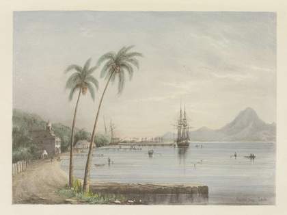
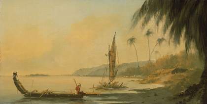
Shipley’s prints are striking, not only on account of their high level of competence, which might not be expected from an amateur naval draughtsman, but also because, when seen in isolation and without the accompanying letterpress, they appear as conventional, picturesque views ignorant of, or oblivious to, this military-imperial context. They are also striking in formal aesthetic terms in that they are conspicuously reminiscent of the views of Pacific environments produced some seventy years earlier on Captain James Cook’s second and third voyages between 1772 and 1780 by the professional artists William Hodges and John Webber. Shipley’s Papeiti Bay Tahiti (fig.1), with its sparsely populated, sweeping, recessive curve of coastline under a light-suffused sky, in which any sign of the Franco-Tahitian conflict is elided, adopts the same formal characteristics as, for example, Hodges’s View from Point Venus, Island of Otaheite, made on the spot in 1773–4 (fig.2).

Fig.1
Conway Shipley
Papeiti Bay Tahiti 1851
Lithograph
Yale Center for British Art, Paul Mellon Collection

Fig.2
William Hodges
View from Point Venus, Island of Otaheite 1773–4
Oil on panel
240 x 470 mm
© National Maritime Museum, Greenwich, UK
The resemblance is not merely coincidental. Shipley’s image was just one of many visual and verbal representations of Tahiti produced in the 1840s, at this particularly critical moment in its history. It might, for example, be compared with the account of another naval lieutenant, Frederick Walpole, written during his four years in the Pacific from 1844–8, who had served on HMS Collingwood on its voyage to Tahiti and Polynesia in 1845 with a similar purpose to Shipley’s three years later.6 What is striking is how Walpole’s textual account of the landscape of Tahiti is, like Shipley’s pictorial one, openly filtered through the eyes of Cook and his artists from the previous century:
It was Sunday on shore as our noble vessel ran along the outside of the reef which encircles the island of Tahiti … As the vessel opened Papiete harbour, instead of the ‘well done, rock and water!’ of the painter, one might exclaim, ‘well done, green and hill!’ An opportune shower had furbished all up, and the houses, with their green background, looked like opals in a setting of emeralds. The bay of Papiete … with a beach of white sand, slopes away with a curve, on the edge of which rise the houses – pretty, long, bungalow buildings, standing separate, and each overshadowed with its own plantation, of bread-fruit and cocoa-nut trees. Behind these rise in every fantastic form and shape, hill above hill, cliff on cliff, till the eye rests on Orifena, seven thousand five hundred feet above the level of the sea. The bases of the hills are covered with trees and vegetation, save that here and there the bare rock appears to give evidence of its presence. Away on the right is a grove of cocoa-nut trees … plants of rarest kinds grow down to the water’s brink, disputing dominion with the sea itself, which, smoothed by the protecting reef, reposes in bluest silvery calmness. On the left are still trees and hills, beauty and nature, till Point Venus, where Cook fixed his observatory, closes in the view.7
Walpole’s effusive rhetoric is remarkable for its painterly description of the land as seen from the sea, and might even be read as a transcription of one of Hodges’s paintings of the same idyllic luminous scene created seventy years earlier.8 He describes the view, like Shipley, in picturesque fashion, as framed by corresponding expanses of trees and hills, until the picture is closed by the spur of Point Venus. This, importantly, aligns the cultural significance of the place and its aestheticised landscape with Captain Cook’s first voyage, made between 1768 and 1771, the principal purpose of which was to observe the transit of Venus from Tahiti.9 In the reference to the “well done, rock and water!” of the painter’, Walpole even alludes to Hodges’s tutor, Richard Wilson, and his celebrated paintings of the Roman campagna. It is a literary description mediated by visual imagery, and Cook and his artists remain the originating reference point for Walpole’s understanding of the visual register of the coastal landscape before him. But what follows takes him far from such visual ownership of the landscape enshrined in the figure of the great national explorer:
But what a change since the great navigator’s day! France has seized the rule, her vessels in warlike array fill the harbour, her drum and martial fifes disturb the sweet songs of the groves, and her flag floats in possession from the most matter-of-fact-looking bastions.10
The significance of Tahiti memorialised in Cook, therefore, is interrupted by the actuality of French occupation, which disrupts Walpole’s sense of the historical order of the place. For Walpole, the significance of Tahiti, emanating from the island’s very landscape, derives from Cook being ‘always already’ there, a continual re-imagining of the island’s geography inscribed with the presence of ‘the great navigator’. Moreover, Cook’s links to Tahiti are also understood as an irrefutable part of the teleology of British national and imperial history, the authorisation of the legitimacy of British claims to the island.
The striking proximity between Shipley’s and Walpole’s visual and verbal descriptions, and their shared ideological agenda in interpreting what they see before them in Tahiti, make it clear that by this date the island was culturally marked out for British visitors, if not quite in the manner of a tourist guide, then certainly in terms of a predetermined set of historically significant sites and landmarks. With these signposts, the island’s coast and landscape could be understood and consumed through a process of re-enactment. As if by way of confirmation, a further visitor, Edward Gennys Fanshawe, on his first voyage both to the Pacific and as Captain of the HMS Daphne, followed directly in the wake of HMS Collingwood and HMS Calypso in visiting Pitcairn, Tahiti and the Society Islands, Fiji and the Friendly Isles between July and September 1849, exactly one year after Conway Shipley’s voyage. His mission, as he explained in his journal and letters home, was also directly related to the prior one of HMS Calypso in checking French ambitions in the region:
The French, I understand, wanted to clutch the Society Islands also [in addition to Tahiti and the Marquesas], but Lord Palmerston got them to enter into a joint guarantee of their independence. This was conveyed to them by the Calypso last year, and the object of my going to those islands is to advise the several chiefs (for each is a separate state) to preserve it.11
Fanshawe is thus well aware of the nature and record of his immediate predecessors’ travels in the region. At the same time, he too is steeped in Cook as the sine qua non of Pacific history and knowledge, and like both Shipley and Walpole, is proleptically attuned to the visual aesthetic of the landscape tradition as the proper means of representing the Pacific. He outlined his preparations for cognitive assimilation, never having before travelled in the region, in a letter to his wife, Jane:
on leaving Callao I shall have to get up Wilkes’s account of the Fijis and Tahiti, Cook’s of the latter, and the correspondence and remarks of my predecessors, Captains Worth and Blake … It is a long interesting voyage, and I hear that the Calypso’s people were enchanted with it. The climate throughout is perfect, and being tropical is, as you know, well suited to me. I hope to make some sketches.12
In addition to his own fellow naval officers’ accounts, then, Fanshawe turns to the American Captain Charles Wilkes’ voyage of 1838–42 and Cook’s of the previous century to provide the necessary data for him to accomplish his mission; and these are, significantly, tied to his anticipation of the natural beauty of the region and his enjoyment and cognitive appropriation of it through making ‘some sketches’.13
Even more than for Walpole and Shipley, word and image for Fanshawe are interchangeable and mutually reinforcing. In a two-day tour of the island he first visited Fautaua, the site of the final stronghold of the Tahitian resistance before they were overcome by the French military and a location to which Walpole and Shipley also paid great attention for its significance in the recent history of the island. The rest of Fanshawe’s tour was dedicated to retracing Cook, through the sites and people associated with him:
Next day we went in the gig to Point Venus, classic ground. This Post is now in charge of a native chief and some native troops, but the former has been to Paris and wears a tight jacket, and the latter are in French pay. There were two huts with fishermen the same tall athletic sort of fellows that Cook might have seen in the same spot, but they were drunk and insolent. We walked round the shores of Matavai Bay till we came to a steep bluff (One Tree Hill), another French Post, thence to Papawa, where is the tomb of old Pomare, the Constantine of Tahiti; but his bones are said to have been carried off and hid by the natives. Queen Pomare has a new house here, built in the old native style, and a good representation of the houses in Cook’s time. It is about 100 feet long and 35 to 40 broad, and rounded at the end, without partition. The sides, as in all genuine Tahitian houses, are of stakes placed upright two or three inches apart … We then proceeded by boat to Saonoa, as I was very anxious to see the old lady who recollected Cook … She is a very fine old woman, 85 years of age or nearly so, for the natives keep no account of their ages. She has a recollection of Wallis and his affray with the natives about 1775 [sic], but not very clear. Of Cook she seems to have a very lively recollection, as indeed she may well if, as I understand, she is the daughter of the unfortunate Tupia whom Cook wished to take to England, but who died at Batavia.14
Although Fanshawe’s history is a little shaky, the urgency of retracing Cook’s steps and acting out his illustrious forebear’s presence in the landscape is at once the key to the historical meaning of Tahiti for Fanshawe, as it was for his naval colleagues, but is also fraught with imminent loss due to the presence of the French on the island. The fishermen, for example, who would otherwise be precise recollections of fishermen from Cook’s era, are now ‘drunk and insolent’, a corrupted shadow of the idealised presence of the great explorer. Queen Pomare herself is understood to be re-enacting the heritage of Cook, through the building of a ‘genuine’ traditional Tahitian house on the ‘classic ground’ of Point Venus and Matavai Bay. Finally, Fanshawe attempts to get as close as he can to ‘re-thinking or re-enacting … in his own mind’ the past actions of Cook, by his ‘very anxious’ determination to meet the last surviving Tahitian to have met Cook in person.
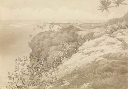
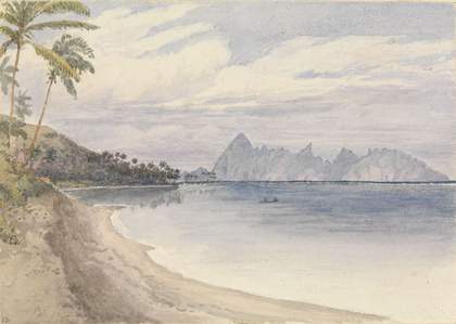
He did also ‘make some sketches’ of the significant sites he encountered on his travels in the South Pacific, which are exactly analogous to his journal entries: the text acting as an explication of the image, and the image becoming the iconic representation of the text. In this sense, Fanshawe’s drawings may be understood themselves as performative, or as forms of re-enactment: artefacts produced in time as part of a continuously unfolding narrative of the voyage itself; that is, produced in the knowledge of what he has already recorded visually and textually, and in anticipation of making similar future records. They are also images made both at and of richly meaningful locations, and created in full consciousness – elaborated in the accompanying text of the journal – of those British visitors who had preceded him, whether recently or in the more distant past, anchored on the pivotal figure of Cook. On the one hand, therefore, his view of Matavai Bay and Point Venus, Tahiti, dated 24 August 1849 (fig.3), was presumably taken from the ‘steep bluff (One Tree Hill)’ that was the midpoint on his day’s outing described in detail in the journal, between Point Venus and Saonoa, and encapsulates in the panoramic view the full moment of the site’s ‘classic ground’, as Cook’s first landing point on the island. On the other hand, his view of Eimeo from near Papeiti (fig.4) was made the following day from almost exactly the same position where Conway Shipley had made his own drawing in the previous year of the same vista (fig.1) in self-conscious imitation of Cook’s artists. In this sense, Fanshawe’s act of drawing is a re-enactment of Shipley’s, which was itself a re-enactment of Cook’s artists in Tahiti. And it is through this process of emulation and imitation as repeatedly acted out in their role as visual recorders of the topography of Tahiti (and other significant sites in the Pacific) that visitors such as Shipley and Fanshawe could represent the landscape of Tahiti as an historical archive of British imperial interests, against the fraught political and ideological backdrop of the Franco-Tahitian war. This in turn is achieved through a process of graphic re-enactment that continually re-inscribes the historical presence of Cook in the landscape as the determining reference point for legitimising British claims to the island. And this form of graphic re-enactment is produced not only in the reiterated appeals to Cook through the sites associated with him but also in the conspicuous adoption of a visual aesthetic deriving from Cook’s voyages as the proper means for representing the island landscape. These and the many similar images of Tahiti and the Pacific of this period are not simply picture-postcard views of a tropical paradise: their apparently innocuous topographical depictions of the Tahitian coastal landscape must be placed firmly within the context of contemporary imperial and geographical history in the Pacific, whereby they can be understood as successive (re-)imaginings of a particular terrain for discrete ideological ends.

Fig.3
Edward Gennys Fanshawe
Matavai Bay and Point Venus, Tahiti 1849
Pencil and pen-and-ink wash on paper
227 x 325 mm
© National Maritime Museum, Greenwich, UK

Fig.4
Edward Gennys Fanshawe
Eimeo from near Papeiti 1849
Watercolour on paper
127 x 179 mm
© National Maritime Museum, Greenwich, UK
The notion of re-enactment as a ‘re-thinking’, or an attempt to ‘re-think’ the thought expressed in a past human action, however problematic such a postulation of history may be from a philosophical perspective, not only offers a potent means of interpreting specific topographical images of a particular place at a particular moment – such as the views of Tahiti discussed here – but also opens up ways of grasping the extraordinary profusion of similar views that were produced from the early to mid-nineteenth century by Western travellers, both amateurs and professional artists, of locations all around the globe: a form of landscape representation that was highly conservative (both formally and iconographically), reiterative and inter-referential. Shipley’s and Fanshawe’s views, therefore, share certain characteristics with the records made by Grand Tourists, in the sense of self-consciously treading earlier footsteps, and memorialising significant sites through the acts of visual and verbal recording. They might also be compared with contemporary performances of art, travel and re-enactment such as William Holman Hunt’s tour through the Holy Land, that resulted in ideologically-loaded – albeit supposedly ‘authentic’ – constructions of biblical history. In the case of the amateur naval artists in mid-1840s Tahiti, art and travel combine to provide a form of re-enactment that is, in the generalised terms in which the historian and literary critic Jonathan Lamb has couched it, ‘memory that refashions the past’; it is a memorialisation produced out of the act of image-making in response to the contingent circumstances of the specific act of travel, which refashions the past by reference to the environment represented through the aesthetics of landscape.15 Re-enacting art and travel, in this instance, is necessarily indistinguishable from the representation of landscape and environment.
