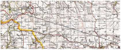
In November 1968 Richard Long made a work on Exmoor by walking for ten miles in a straight line on a compass bearing of 290 degrees. The work was documented by the relevant section of the one-inch Ordnance Survey map on which the line of the walk was drawn in pencil, with the inscription below: ‘A Ten Mile Walk England 1968’ (fig.1). It is a significant work in Long’s career because of its unprecedented scale (a ten mile invisible ‘sculpture’) and also on account of the unique environment in which he chose to make it.1 This paper explores the implications of the action and the terrain in which it was made, since the former is not so simple nor the latter as empty as has sometimes been suggested.

Fig.1
Richard Long
A Ten Mile Walk England 1968
Map and graphite
640 x 690 mm
Private collection. Courtesy Konrad Fischer Gallery
© Richard Long
The inevitable comparison with Line Made by Walking (Tate P07149) of the previous year testifies to a shift in Long’s practice.2 While that work was made by walking up and down a few yards of nondescript meadow, A Ten Mile Walk England involved sustained walking across difficult ground, and while the earlier piece was recorded in an unassuming photograph conveying no indication of specific place, the cartographic ‘found object’ that documents the later work not only situates it in a particular landscape but brings with it a rush of further information. The arena in which the walk was made was more properly ‘scenery’, part of a National Park, an area of outstanding natural beauty.
This scenic aspect, however, has been regarded as no more than incidental by most interpreters of the work, taking their cue from the artist himself, and in no way bound up with its meaning. The piece is usually understood as a simple, large-scale figure laid down or performed in a space chosen essentially for its convenience, that is, for its emptiness and remoteness. According to R.H. Fuchs, author of the first monograph on the artist, Exmoor ‘was conveniently near … and had the right topography, being open and rolling … The map showed no great obstacles… It would be a straight, uninterrupted and, in terms of covering the projected distance, smooth walk – direct and uneventful’. 3 But the idea of Exmoor as a tabula rasa needs to be contested, for although Long’s route traverses some genuinely open and apparently desolate tracts, particularly those in the vicinity of the Chains, in practice it would be very difficult to project a straight line of ten uninterrupted miles anywhere on the moor, and it would also have involved the negotiation of many enclosures and boundaries.
The line was evidently plotted carefully to take advantage of the continuous ridge of high ground running roughly north-west to south-east from Parracombe to Exford. As drawn on the one inch map, this may indeed give the impression of a traverse of high, open country, but when the line is projected on the larger scale map at two and a half inches to the mile (the scale most useful to walkers) a rather different picture emerges. At this scale field boundaries are shown, and even allowing for slight changes in the configuration of field patterns since 1968, it is evident that the ten-mile line would have meant crossing some sixty fences, hedges, banks or other obstacles. Right from the start, at a point on the lane to Warren Farm just off the Simonsbath-Exford road, the line of the walk crosses a series of enclosed fields before reaching open moorland at Dure Down some two and a half miles further west. But it is the three-mile stretch of the line west of the Somerset-Devon border that would have imposed the most hectic pace of trespass. This is tightly folded, intensively farmed, awkward terrain, entirely typical of the Exmoor margins. It involves the passage of a series of steep-sided combes before coming to an end in the rising contours of Cowley Wood.
Seen in this light, the character of the walk appears rather different from that uninterrupted, smooth, uneventful progress imagined by Fuchs, and it complicates Long’s own later account of his practice as ‘the laying down of modern ideas in the only practical places to take them’.4 But the Exmoor piece, like much of his other work of the late 1960s, has an absurdist aspect that has become lost to critical view, overlaid as it has been by much of Long’s subsequent practice, and by the dominant interpretations of it as ‘a straightforward act of engagement with nature’. 5 Indeed A Ten Mile Walk England has more in common with Simon Faithfull’s video 0.00 Degree Navigation, involving a walk (and occasional swim) along the Greenwich Meridian, in which the artist follows a rigorous conceptual brief and an abstract line through situations of escalating difficulty and absurdity, and which appears to be a parody of the walking-as-art strategies of the kind Long himself had made so familiar. But in his Exmoor piece, the repeated small acts of trespass might be taken as animated by something of that spirit of rebellion that was more widely evident in radical culture in Britain towards the end of the 1960s. Long had only recently left art college, and his work can perhaps be understood as the assertion of freedom in a world of enclosures and divisions, the freedom to move across all kinds of boundary.
The direction of Long’s walk may have been designed to make the fullest use of such wild, open country as Exmoor could provide (although it is as much a landscape of enclosure as of open space, and barely half the ten miles could be followed across the unrestricted moor), but what factors determined its precise alignment? It is surely not just a coincidence that the line of the walk as it is drawn on Long’s map passes through the exact centre of the X of Exmoor as it was printed on the sheet. Of course this X only exists on the map and not on the ground: X marks a spot where there is nothing special to see. But if we look more closely at the map, we can observe that the X happens to be printed very close to the source of the River Exe itself at Exe Head. This is pure cartographic chance, beyond question: the letter X is related to the conceptual aspect of the map, whereas Exe Head indicates the representational part. But the play on text and site is richly suggestive: the X precisely crossed by the line of the walk brings out very neatly the intersection of action, idea, place and symbol in Long’s practice, preoccupations that are also indicated by another work done earlier that same year, simply titled England 1968, in which the X is actually traced on the ground by the physical intervention of the artist (fig.2). The map inscribed with a cross is a common trope of geography and fiction, but this X refers only to itself, an autonomous mark, an ephemeral sign.

The point where the line of the walk transects the X of Exmoor may be invisible on the ground, but the line also coincides precisely with an unequivocally material feature, since it passes along the top of the dam at the southern end of Pinkworthy Pond (fig.3). It is surely this coincidence that determines the exact alignment of the walk, and it comes, moreover, at exactly the half-way point along it. Pinkworthy Pond (pronounced ‘Pinkery’) is perhaps the most enigmatic feature of this part of the moor. It is not a natural lake but a result of the enterprise of landowner and industrialist John Knight (1765–1850), who dammed the headsprings of the River Barle to create it, so that the pond now appears as the source of the river itself. (Long’s walk, therefore, passes the source of both of Exmoor’s great rivers, rising within two miles of each other in this notoriously boggy heartland of the moor.) The purpose of the dam is unclear. It has been suggested that it was connected with mining, constructed to provide a source of water-power, but there is no historical evidence for this and it is perhaps more likely to be related to some scheme of irrigation that was subsequently abandoned.

Fig.3
Detail of Ordnance Survey map of Exmoor
© Ordnance Survey
Despite its initial appearance as an untouched wilderness, that part of the Chains traversed by Long in the central section of his piece is therefore revealed, on closer investigation, to be a space of large-scale human intervention and enterprise. The line of prehistoric barrows that mark the ridge that his route followed are an obvious sign of much earlier ritual activity, but the landscape had been profoundly modified in a more recent historical period. The first half of A Ten Mile Walk England is conducted in the northern part of what has been described as an Exmoor empire, belonging to John Knight and his son Frederick, among the most ambitious and determined of all nineteenth-century entrepreneurs and improvers. The agricultural economist and historian C.S. Orwin called it ‘the last big piece of land reclamation that has taken place in England’, and regarded it as one of the most stupendous achievements of its kind from the nineteenth century. 6
John Knight purchased an enormous tract of the Forest of Exmoor from the Crown, following an Act of Inclosure passed in 1815, with the intention of making the land productive. (Significantly, one of his ancestors was the landscape theorist, improver and landscape gardener Richard Payne Knight, whose Herefordshire estate, Downton Castle, has been the subject of much interest on the part of landscape historians. 7 ) By 1820 Knight had acquired more than fifteen thousand acres on Exmoor and set out to reclaim it by draining, enclosing, planting, prospecting, stocking and fertilising, and by building roads and farms. His son Frederick succeeded him after 1841 and pursued the colossal project with even more energy, at least until 1879. This whole episode has sometimes been interpreted as a story of hubris, delusion and folly, of inappropriate methods and frustrated schemes. Pinkworthy Pond, and the still more enigmatic earthworks nearby, the beginnings, perhaps, of a canal or irrigation channel, can be read as symbols of the ultimate failure of their project. In this post-romantic view, the implacable widerness prevails over the vain schemes of mercenary men.
C.S. Orwin took a more positive view in his classic history The Reclamation of Exmoor Forest, first published in 1929. For Orwin, the Knights were the makers of Exmoor, and the moor was their monument. 8 They found a waste, almost untouched by man, not crossed by any road, unfenced, virtually uninhabited and ecologically derelict (the government Commissioners Survey of 1814 counted only thirty-seven trees in the whole extent of the Royal Forest).9 Their great project may not have delivered all that they expected in terms of wealth, but they succeeded in bringing about a profound transformation of the environment: they socialised it and tamed it. Orwin was convinced that farming on Exmoor was a viable project, and he considered that the productivity of the moor in his own time was the ultimate vindication of the vision of the Knights.10
Richard Long’s straight, immaterial line cuts across the huge configurations of land already inscribed across the Exmoor landscape by the Knights with their enclosure walls. Both the outermost boundary of their estate and the many subdivisions within it are formed by monumental dry-stone walls covered in earth, often running in straight lines, as if to articulate the imposition of a rational order on an inchoate space. For a considerable stretch of his walk across the highest ground, Long was following the so-called Chains Wall, a boundary that separates the unimproved bog from the series of large, relatively productive enclosures of Pinkworthy Farm to the south, and the route of a recognised bridleway. The line of his walk does not coincide with the wall exactly but shears across the difficult terrain on its northern side, before converging with the wall as it nears the dam at Pinkworthy Pond. His rigorously predetermined line of action almost inevitably commits him to a departure from existing paths, even though they are often in close proximity.
Long’s walk is directly referenced in a book by writer Shirley Toulson, The Moors of the Southwest: Exploring the Ancient Tracks of Sedgemoor and Exmoor, published in 1983. 11 This is an example of a familiar genre, a collection of walks to be undertaken for pleasure, though perhaps one unusually attentive to local detail and artistic association. Toulson’s interest is in retracing ancient pathways, ridgeways, pilgrim routes and drove roads. Walk 8 in the book is ‘Richard Long’s Exmoor Walk’, and her claim that the artist must have realised ‘he was following an ancient trading route, marked out by barrows and confirmed in later centuries by … chapmen and pedlars’ need not be taken as a binding interpretation of his project. 12 Avant-garde practice and recreational walking belong to different worlds of activity, as Toulson is well aware, and she acknowledges that it is not practical to follow literally in the artist’s footsteps, nor even rewarding from her point of view, just as Long himself would resist the idea that the sites of his work could be revisited by others (‘the place should be anonymous in the art world’). 13 The many departures she suggests from his unwavering adherence to that 290 degree compass bearing make tactful use of rights of way as well as open access land, and are guided too by a sense of scenic value. Her fascinating publication, unremarked in the literature on Long, serves to make clear the distinction between a walk undertaken as art and one taken for leisure.
The artist began the walk, as noted earlier, from the lane leading to Warren Farm, a mile or so north-east of Simonsbath. This is one of the farms established by Frederick Knight, a seven hundred-acre enclosure won from the moor at its boggiest and most unpromising and was first tenanted by 1850. After crossing two fields, Long would have passed the springs of White Water, just above Cloven Rocks Bridge. At this point he intersected the trace of another of the ‘makers’ of Exmoor, a maker this time working on the plane of the imaginary. For it was in this location that the writer R.D. Blackmore chose to set the violent climax of his novel Lorna Doone. He has his villain Carver Doone pursued down beyond Cloven Rocks by the hero John Ridd, and after a struggle Carver meets his terrible end: ‘the black bog had him by the feet, the sucking of the ground drew on him, like the thirsty lips of death’. 14

Keith Arnatt
Self-Burial (Television Interference Project) (1969)
Tate
Blackmore’s novel first appeared in 1869. It is set in the seventeenth century and imagines a still untamed Exmoor, though it is interesting to note that the very period in which it was conceived and written is also that of the continuing reclamations and improvements of Frederick Knight. It could be argued that Blackmore’s novel did just as much for the prosperity of Exmoor, and the transformation of its image: its huge success brought tourists in to experience the Doone Country, and in doing so creating a minor industry. Exmoor became a literary landscape, a tourist destination.
Carver Doone’s fate may not have crossed Long’s mind as he headed west towards Exe Head and the forbidding terrain of the Chains. Besides, White Water is several miles away from ‘Doone Valley’, and has never been part of any tourist trail. Long may only have considered the landscape in front of him as a suitable arena for action, a good place to further his project to create an alternative kind of sculptural practice in the open air. He had chosen to make his work in a place he knew well, though, since the moorlands of the south-west were a familiar stamping ground from childhood expeditions with his parents. 15 (It is noticeable that Long has gradually come to allow the autobiographical aspect of his art, and particularly his relationship to the West Country, to become more evident in his exhibitions and accompanying publications.) A Ten Mile Walk England may well have been planned and undertaken without any explicit acknowledgement that it involved traversing the country of the Knights and Doones. But his work was made in an environment that had already been subject to multiple histories of transformation: physical, economic and imaginative; his immaterial gesture has come to have its own resonance within that complex space.
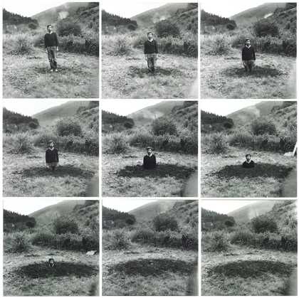
The form in which Long chose to document his ten-mile, winter traverse of Exmoor is laconic enough, making no reference to the physical challenges, scenic value or historic associations of the landscape. But his crossing of White Water and the notorious bogs of the Chains brings another work of art to mind, made only a year later: Keith Arnatt’s Self Burial (Television Interference Project) (fig.4). 16 Here the artist presented himself sinking inch by inch every night for a week in October 1969 on German television, a deadpan Carver Doone. As the last line of Blackmore’s penultimate chapter has it: ‘Scarcely could I turn away, while joint by joint, he sank from sight’. 17 The connection is irresistible.


